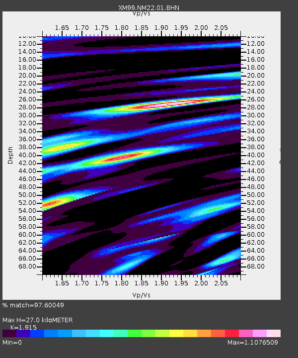
NM22 NewMexico22 - Earthquake Result Viewer
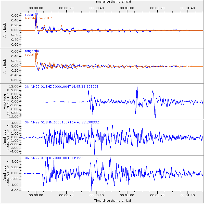
Earthquake location: Windward Islands
Earthquake latitude/longitude: 11.1/-62.6
Earthquake time(UTC): 2000/10/04 (278) 14:37:44 GMT
Earthquake Depth: 110 km
Earthquake Magnitude: 5.6 MB, 5.4 MS, 6.1 MW, 5.9 MD
Earthquake Catalog/Contributor: WHDF/NEIC
Network: XM Rio Grande Seismic Transect
Station: NM22 NewMexico22
Lat/Lon: 33.84 N/105.87 W
Elevation: 1691 m
Distance: 45.5 deg
Az: 306.853 deg
Baz: 109.342 deg
Ray Param: 0.0708446
Estimated Moho Depth: 27.0 km
Estimated Crust Vp/Vs: 1.91
Assumed Crust Vp: 6.232 km/s
Estimated Crust Vs: 3.254 km/s
Estimated Crust Poisson's Ratio: 0.31
Radial Match: 97.60049 %
Radial Bump: 400
Transverse Match: 90.33479 %
Transverse Bump: 400
SOD ConfigId: 16820
Insert Time: 2010-02-26 17:23:45.726 +0000
GWidth: 2.5
Max Bumps: 400
Tol: 0.001

Signal To Noise

ChannelStoNSTALTA
XM:NM22:01:BHN:20001004T14:45:22.20899Z2.48176482.771171E-71.116613E-7
XM:NM22:01:BHE:20001004T14:45:22.20899Z6.83029849.179271E-71.3439049E-7
XM:NM22:01:BHZ:20001004T14:45:22.20899Z12.8867532.1605324E-61.676553E-7
Arrivals
Ps4.2 SECOND
PpPs12 SECOND
PsPs/PpSs16 SECOND