
Station XM NM22 - NewMexico22
Network: XM99 - Rio Grande Seismic Transect
Nearby stations (2 deg radius)
| Station | Name | (Lat, Lon) | Start / End | Elevation |
| NM22 | NewMexico22 | (33.84, -105.87) | 1999-10-01 / 2001-12-31 | 1691 m |
| Crust2 Type: | P2,orogen/38km, Alps and Foreland, 2 km seds. |
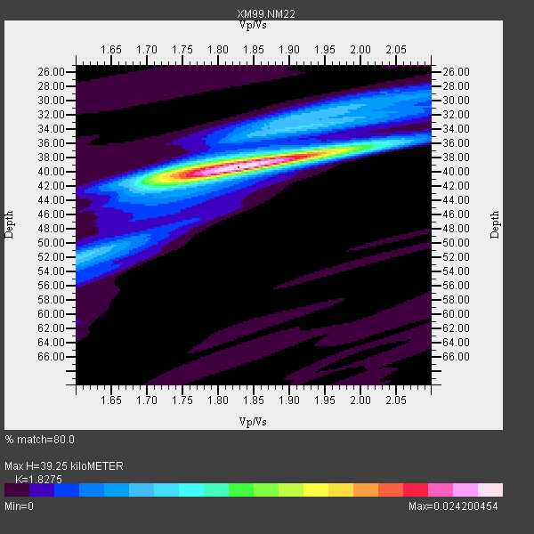
| Thickness Estimate: | 39 km |
| Thickness StdDev: | 0.6 km |
| Vp/Vs Estimate: | 1.83 |
| Vp/Vs StdDev: | 0.03 |
| Vs Estimate: | 3.41 km/s |
| Poisson's Ratio: | 0.29 |
| Peak Value: | 0.02 |
| Assumed Vp: | 6.232 km/s |
| Ps Weight: | 0.33333334 |
| PpPs Weight: | 0.33333334 |
| PsPs Weight: | 0.33333328 |
| Residual Complexity: | 0.432 |
| Nearby stations H: | +- |
| (2.0 deg) Vp/Vs: | +- |
9 with match > 90% ( 33.333332 %) and 26 with match > 80% ( 96.296295 %) out of 27.
Download stack as xyz text file.
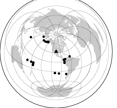
Azimuth Distribution of Events:
Prior Results for this Station
| Study | Thickness | Vp/Vs | Vp | Vs | Poissons Ratio | Extra |
| EARS | 39 km | 1.83 | 6.232 km/s | 3.41 km/s | 0.29 | |
| Crust2.0 | 38 km | 1.76 | 6.232 km/s | 3.534 km/s | 0.26 | P2,orogen/38km, Alps and Foreland, 2 km seds. |
| Wilson | 40 km | 1.78 | 6.21 km/s | 3.489 km/s | 0.27 | |
| Global Maxima | 39 km | 1.83 | 6.232 km/s | 3.41 km/s | 0.29 | amp=0.024200454 |
| Local Maxima 1 | 40 km | 1.75 | 6.232 km/s | 3.556 km/s | 0.26 | amp=0.009474095 |
| Local Maxima 2 | 52 km | 1.60 | 6.232 km/s | 3.889 km/s | 0.18 | amp=0.0070143766 |
| Local Maxima 3 | 37 km | 1.98 | 6.232 km/s | 3.155 km/s | 0.33 | amp=0.0060895206 |
| Local Maxima 4 | 31 km | 1.96 | 6.232 km/s | 3.183 km/s | 0.32 | amp=0.005336253 |
| Predicted Arrivals for vertical incidence (zero ray parameter) | |
| Ps | 5.21 SECOND |
| PpPs | 17.81 SECOND |
| PsPs/PpSs | 23.02 SECOND |
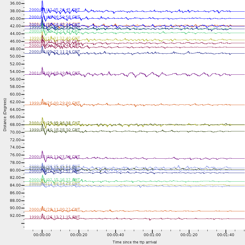
Events Processed for this Station
Download zip of receiver functions as SAC
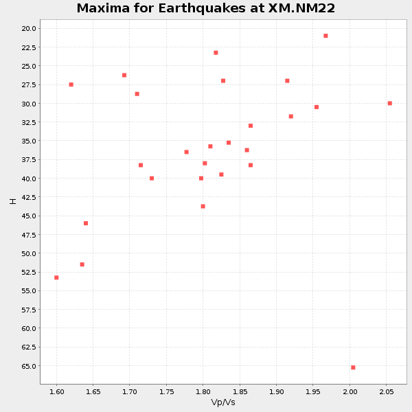
Plot maxima for each earthquake.
Events Used in the Stack
(26 events)| Radial Match | Distance | Baz | FERegion | Time | Lat/Lon | Depth | Magnitude |
| 97.60049 | 45.5 deg | 109.342 deg | Windward Islands | 2000/10/04 14:37:44 GMT | (11.1, -62.6) | 110 km | 5.6 MB, 5.4 MS, 6.1 MW, 5.9 MD |
| 97.26513 | 93.4 deg | 299.623 deg | Volcano Islands, Japan Region | 2000/03/28 11:00:22 GMT | (22.3, 143.7) | 126 km | 6.8 MB, 7.6 MS, 7.6 MW, 7.6 MW |
| 96.49253 | 95.7 deg | 254.152 deg | Vanuatu Islands | 1999/11/26 13:21:15 GMT | (-16.4, 168.2) | 33 km | 6.4 MB, 7.3 MS, 7.5 MW, 7.3 MW |
| 94.5728 | 41.4 deg | 139.734 deg | Near Coast Of Ecuador | 2000/09/28 23:23:43 GMT | (-0.2, -80.6) | 23 km | 5.8 MB, 6.0 MS, 6.6 MW, 6.4 MW |
| 94.23267 | 40.2 deg | 321.011 deg | Kodiak Island Region, Alaska | 1999/12/06 23:12:33 GMT | (57.4, -154.5) | 66 km | 6.8 MB, 7.0 MW, 7.0 ML |
| 93.73092 | 82.3 deg | 243.489 deg | Tonga Islands | 2000/09/26 06:17:52 GMT | (-17.2, -173.9) | 56 km | 6.1 MB, 6.1 MS, 6.4 MW, 6.1 ME |
| 92.6466 | 39.4 deg | 320.787 deg | Kodiak Island Region, Alaska | 2001/01/10 16:02:44 GMT | (57.1, -153.2) | 33 km | 6.2 MB, 6.8 MS, 7.1 MW, 6.8 ML |
| 90.5548 | 40.2 deg | 320.929 deg | Kodiak Island Region, Alaska | 1999/12/07 00:19:49 GMT | (57.4, -154.5) | 41 km | 6.5 MB, 6.1 MS, 6.4 MW, 6.3 ML |
| 90.41368 | 35.1 deg | 137.009 deg | South Of Panama | 2000/12/12 05:26:45 GMT | (6.0, -82.7) | 10 km | 5.8 MB, 5.7 MS, 6.3 ME, 6.1 MW |
| 89.97133 | 37.2 deg | 129.471 deg | Panama-Colombia Border Region | 2000/11/08 06:59:58 GMT | (7.0, -77.8) | 17 km | 6.0 MB, 6.4 MS, 6.5 MW, 6.2 ML |
| 88.974754 | 62.3 deg | 319.598 deg | Komandorskiye Ostrova Region | 1999/11/26 00:29:00 GMT | (55.1, 165.4) | 33 km | 5.6 MB, 5.8 MS |
| 88.30071 | 81.3 deg | 244.364 deg | Tonga Islands | 2000/09/11 17:17:53 GMT | (-15.9, -173.7) | 115 km | 6.0 MB, 6.3 MW, 6.3 MW |
| 87.73166 | 84.7 deg | 240.875 deg | Tonga Islands | 2000/01/02 15:16:32 GMT | (-20.8, -174.2) | 33 km | 5.5 MB, 5.8 MS, 5.8 MW, 5.8 MW |
| 87.26487 | 68.2 deg | 183.184 deg | Southern East Pacific Rise | 2000/10/25 19:00:17 GMT | (-34.7, -109.5) | 10 km | 5.6 MB, 5.7 MS, 6.1 MW, 6.1 MW |
| 86.81327 | 44.4 deg | 143.316 deg | Near Coast Of Northern Peru | 2000/05/22 13:15:08 GMT | (-4.1, -81.1) | 33 km | 5.3 MB, 5.4 MS, 5.8 MW, 5.8 MW |
| 86.78792 | 43.4 deg | 315.961 deg | Alaska Peninsula | 1999/10/13 01:33:40 GMT | (54.7, -161.2) | 30 km | 6.0 MB, 6.2 MS, 6.5 MW, 6.0 ML |
| 86.18881 | 70.1 deg | 172.652 deg | West Chile Rise | 1999/12/10 18:38:30 GMT | (-36.2, -97.3) | 10 km | 5.7 MB, 6.2 MS, 6.5 MW, 6.5 MW |
| 86.0017 | 39.3 deg | 319.314 deg | Kodiak Island Region, Alaska | 2000/11/06 11:40:26 GMT | (56.2, -153.5) | 20 km | 5.5 MB, 5.6 MS, 6.0 MW, 5.5 ML |
| 85.76835 | 85.8 deg | 240.312 deg | Tonga Islands | 2000/08/17 00:04:29 GMT | (-21.9, -174.8) | 33 km | 5.4 MB, 5.8 MS, 5.9 MW, 5.7 MW |
| 83.33174 | 68.2 deg | 183.357 deg | Southern East Pacific Rise | 2000/10/25 05:26:38 GMT | (-34.6, -109.6) | 10 km | 5.6 MB, 5.7 MS, 6.0 MW, 6.0 MW |
| 82.99404 | 47.3 deg | 312.89 deg | Fox Islands, Aleutian Islands | 2000/12/05 22:11:34 GMT | (52.6, -167.8) | 33 km | 5.6 MB, 5.6 MS, 5.9 MW, 5.4 ML |
| 81.982025 | 81.5 deg | 244.516 deg | Tonga Islands | 1999/12/07 21:29:49 GMT | (-15.9, -174.0) | 138 km | 6.2 MB, 6.4 MW, 6.4 MW |
| 80.895836 | 53.6 deg | 312.301 deg | Andreanof Islands, Aleutian Is. | 2001/02/01 18:19:30 GMT | (51.4, -177.8) | 33 km | 5.6 MB, 5.6 MS, 6.0 MW, 5.9 MW |
| 80.547966 | 80.8 deg | 244.553 deg | Tonga Islands | 2000/11/09 05:45:54 GMT | (-15.4, -173.4) | 53 km | 5.6 MB, 5.9 MW, 5.7 MW |
| 80.22351 | 86.2 deg | 248.321 deg | Fiji Islands | 2000/09/14 14:59:57 GMT | (-15.7, 179.8) | 33 km | 5.7 MB, 6.2 MS, 6.3 MW, 6.2 MW |
| 80.02896 | 78.0 deg | 155.629 deg | Off Coast Of Central Chile | 2000/12/20 11:23:54 GMT | (-39.0, -74.7) | 11 km | 6.1 MB, 6.2 MS, 6.4 MW, 6.0 ME |
Losers
(1 events)| Radial Match | Distance | Baz | FERegion | Time | Lat/Lon | Depth | Magnitude | Reason |
| 95.841934 | 97.2 deg | 248.5 deg | Southeast Of Loyalty Islands | 2001/02/28 13:05:31 GMT | (-22.0, 170.1) | 10 km | 5.8 MB, 6.1 MS, 6.2 MW |
