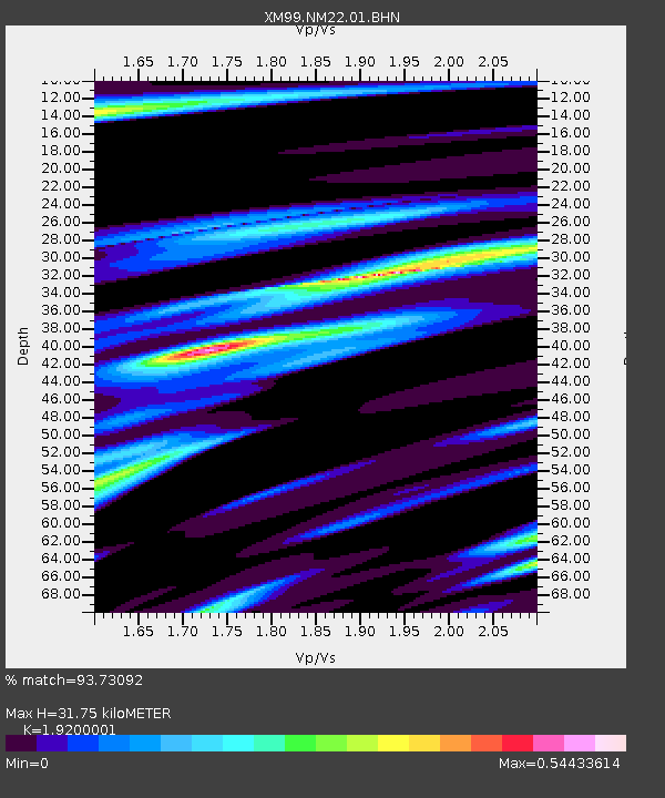
NM22 NewMexico22 - Earthquake Result Viewer

Earthquake location: Tonga Islands
Earthquake latitude/longitude: -17.2/-173.9
Earthquake time(UTC): 2000/09/26 (270) 06:17:52 GMT
Earthquake Depth: 56 km
Earthquake Magnitude: 6.1 MB, 6.1 MS, 6.4 MW, 6.1 ME
Earthquake Catalog/Contributor: WHDF/NEIC
Network: XM Rio Grande Seismic Transect
Station: NM22 NewMexico22
Lat/Lon: 33.84 N/105.87 W
Elevation: 1691 m
Distance: 82.3 deg
Az: 51.18 deg
Baz: 243.489 deg
Ray Param: 0.046905495
Estimated Moho Depth: 31.75 km
Estimated Crust Vp/Vs: 1.92
Assumed Crust Vp: 6.232 km/s
Estimated Crust Vs: 3.246 km/s
Estimated Crust Poisson's Ratio: 0.31
Radial Match: 93.73092 %
Radial Bump: 400
Transverse Match: 89.98003 %
Transverse Bump: 400
SOD ConfigId: 16820
Insert Time: 2010-02-26 17:23:48.179 +0000
GWidth: 2.5
Max Bumps: 400
Tol: 0.001

Signal To Noise

ChannelStoNSTALTA
XM:NM22:01:BHN:20000926T06:29:36.717007Z3.69533013.2612581E-78.82535E-8
XM:NM22:01:BHE:20000926T06:29:36.717007Z5.33970264.4802874E-78.390519E-8
XM:NM22:01:BHZ:20000926T06:29:36.717007Z17.7688371.5563999E-68.7591545E-8
Arrivals
Ps4.8 SECOND
PpPs15 SECOND
PsPs/PpSs19 SECOND