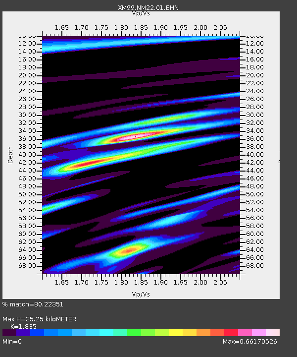
NM22 NewMexico22 - Earthquake Result Viewer

Earthquake location: Fiji Islands
Earthquake latitude/longitude: -15.7/179.8
Earthquake time(UTC): 2000/09/14 (258) 14:59:57 GMT
Earthquake Depth: 33 km
Earthquake Magnitude: 5.7 MB, 6.2 MS, 6.3 MW, 6.2 MW
Earthquake Catalog/Contributor: WHDF/NEIC
Network: XM Rio Grande Seismic Transect
Station: NM22 NewMexico22
Lat/Lon: 33.84 N/105.87 W
Elevation: 1691 m
Distance: 86.2 deg
Az: 53.436 deg
Baz: 248.321 deg
Ray Param: 0.04420943
Estimated Moho Depth: 35.25 km
Estimated Crust Vp/Vs: 1.84
Assumed Crust Vp: 6.232 km/s
Estimated Crust Vs: 3.396 km/s
Estimated Crust Poisson's Ratio: 0.29
Radial Match: 80.22351 %
Radial Bump: 400
Transverse Match: 65.88299 %
Transverse Bump: 400
SOD ConfigId: 16820
Insert Time: 2010-02-26 17:23:49.459 +0000
GWidth: 2.5
Max Bumps: 400
Tol: 0.001

Signal To Noise

ChannelStoNSTALTA
XM:NM22:01:BHN:20000914T15:12:04.279009Z1.13868565.0738134E-84.455851E-8
XM:NM22:01:BHE:20000914T15:12:04.279009Z1.9026131.3679599E-77.189901E-8
XM:NM22:01:BHZ:20000914T15:12:04.279009Z2.7684262.2157734E-78.00373E-8
Arrivals
Ps4.8 SECOND
PpPs16 SECOND
PsPs/PpSs21 SECOND