You are here: Home > Network List > XM99 - Rio Grande Seismic Transect Stations List
> Station NM22 NewMexico22 > Earthquake Result Viewer
NM22 NewMexico22 - Earthquake Result Viewer

| Earthquake location: |
Kodiak Island Region, Alaska |
| Earthquake latitude/longitude: |
57.4/-154.5 |
| Earthquake time(UTC): |
1999/12/06 (340) 23:12:33 GMT |
| Earthquake Depth: |
66 km |
| Earthquake Magnitude: |
6.8 MB, 7.0 MW, 7.0 ML |
| Earthquake Catalog/Contributor: |
WHDF/NEIC |
|
| Network: |
XM Rio Grande Seismic Transect |
| Station: |
NM22 NewMexico22 |
| Lat/Lon: |
33.84 N/105.87 W |
| Elevation: |
1691 m |
|
| Distance: |
40.2 deg |
| Az: |
104.604 deg |
| Baz: |
321.011 deg |
| Ray Param: |
0.07435158 |
| Estimated Moho Depth: |
36.5 km |
| Estimated Crust Vp/Vs: |
1.78 |
| Assumed Crust Vp: |
6.232 km/s |
| Estimated Crust Vs: |
3.506 km/s |
| Estimated Crust Poisson's Ratio: |
0.27 |
|
| Radial Match: |
94.23267 % |
| Radial Bump: |
400 |
| Transverse Match: |
86.05565 % |
| Transverse Bump: |
400 |
| SOD ConfigId: |
27569 |
| Insert Time: |
2010-02-26 17:23:58.141 +0000 |
| GWidth: |
2.5 |
| Max Bumps: |
400 |
| Tol: |
0.001 |
|
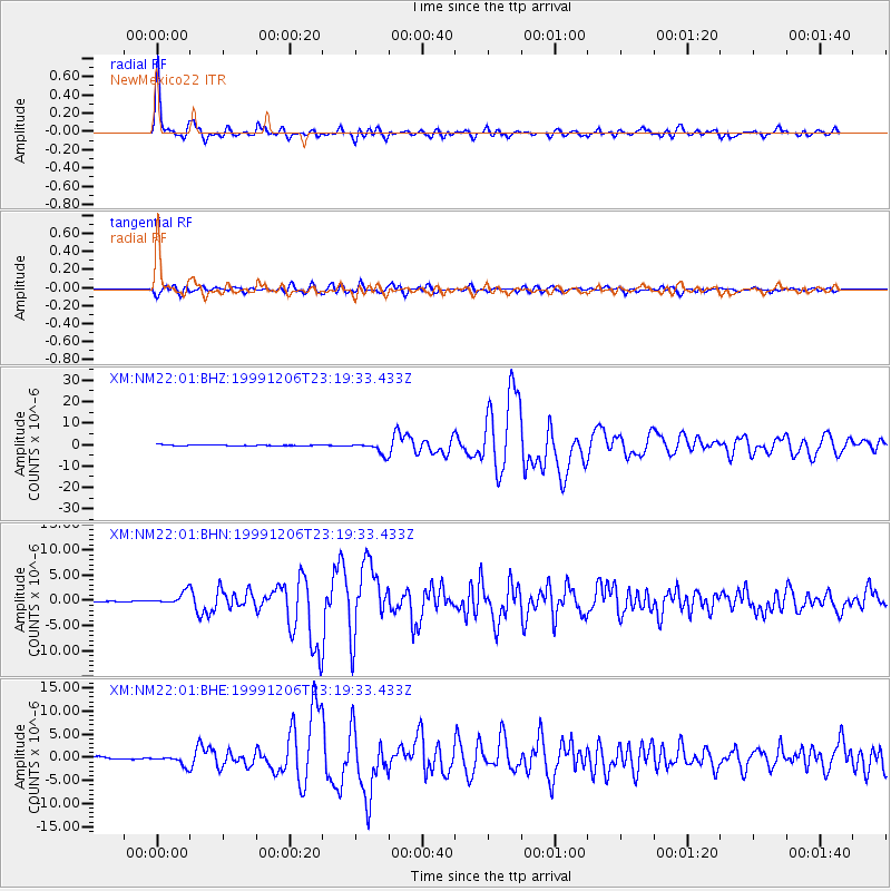
Signal To Noise
| Channel | StoN | STA | LTA |
| XM:NM22:01:BHN:19991206T23:19:33.433Z | 11.057787 | 1.227931E-6 | 1.1104672E-7 |
| XM:NM22:01:BHE:19991206T23:19:33.433Z | 5.3094354 | 1.0869984E-6 | 2.0472957E-7 |
| XM:NM22:01:BHZ:19991206T23:19:33.433Z | 17.316612 | 2.738205E-6 | 1.5812591E-7 |
| Arrivals |
| Ps | 4.9 SECOND |
| PpPs | 15 SECOND |
| PsPs/PpSs | 20 SECOND |


