You are here: Home > Network List > XM99 - Rio Grande Seismic Transect Stations List
> Station NM22 NewMexico22 > Earthquake Result Viewer
NM22 NewMexico22 - Earthquake Result Viewer
| Earthquake location: |
Tonga Islands |
| Earthquake latitude/longitude: |
-15.9/-174.0 |
| Earthquake time(UTC): |
1999/12/07 (341) 21:29:49 GMT |
| Earthquake Depth: |
138 km |
| Earthquake Magnitude: |
6.2 MB, 6.4 MW, 6.4 MW |
| Earthquake Catalog/Contributor: |
WHDF/NEIC |
|
| Network: |
XM Rio Grande Seismic Transect |
| Station: |
NM22 NewMexico22 |
| Lat/Lon: |
33.84 N/105.87 W |
| Elevation: |
1691 m |
|
| Distance: |
81.5 deg |
| Az: |
51.341 deg |
| Baz: |
244.516 deg |
| Ray Param: |
0.047206316 |
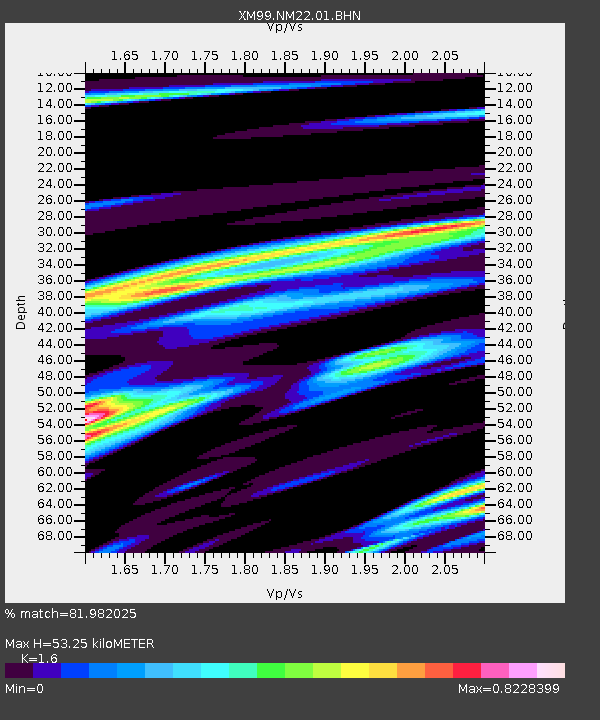
| Estimated Moho Depth: |
53.25 km |
| Estimated Crust Vp/Vs: |
1.60 |
| Assumed Crust Vp: |
6.232 km/s |
| Estimated Crust Vs: |
3.895 km/s |
| Estimated Crust Poisson's Ratio: |
0.18 |
|
| Radial Match: |
81.982025 % |
| Radial Bump: |
400 |
| Transverse Match: |
59.97082 % |
| Transverse Bump: |
400 |
| SOD ConfigId: |
27569 |
| Insert Time: |
2010-02-26 17:24:01.223 +0000 |
| GWidth: |
2.5 |
| Max Bumps: |
400 |
| Tol: |
0.001 |
|

Signal To Noise
| Channel | StoN | STA | LTA |
| XM:NM22:01:BHN:19991207T21:41:20.332012Z | 2.1109557 | 4.1268083E-7 | 1.9549478E-7 |
| XM:NM22:01:BHE:19991207T21:41:20.332012Z | 3.0261197 | 5.9580503E-7 | 1.9688747E-7 |
| XM:NM22:01:BHZ:19991207T21:41:20.332012Z | 9.612918 | 1.4968928E-6 | 1.5571679E-7 |
| Arrivals |
| Ps | 5.3 SECOND |
| PpPs | 22 SECOND |
| PsPs/PpSs | 27 SECOND |


