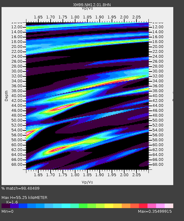
NM12 NewMexico12 - Earthquake Result Viewer
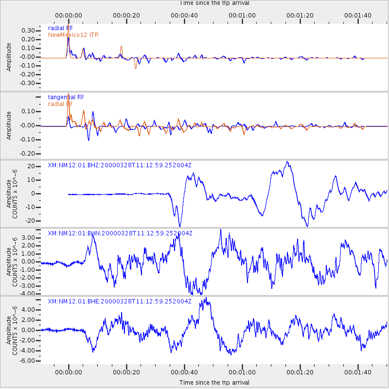
Earthquake location: Volcano Islands, Japan Region
Earthquake latitude/longitude: 22.3/143.7
Earthquake time(UTC): 2000/03/28 (088) 11:00:22 GMT
Earthquake Depth: 126 km
Earthquake Magnitude: 6.8 MB, 7.6 MS, 7.6 MW, 7.6 MW
Earthquake Catalog/Contributor: WHDF/NEIC
Network: XM Rio Grande Seismic Transect
Station: NM12 NewMexico12
Lat/Lon: 32.68 N/104.51 W
Elevation: 1066 m
Distance: 95.0 deg
Az: 51.828 deg
Baz: 300.334 deg
Ray Param: 0.040816527
Estimated Moho Depth: 55.25 km
Estimated Crust Vp/Vs: 1.60
Assumed Crust Vp: 6.232 km/s
Estimated Crust Vs: 3.895 km/s
Estimated Crust Poisson's Ratio: 0.18
Radial Match: 98.48489 %
Radial Bump: 379
Transverse Match: 93.324104 %
Transverse Bump: 400
SOD ConfigId: 27569
Insert Time: 2010-02-26 17:24:32.975 +0000
GWidth: 2.5
Max Bumps: 400
Tol: 0.001

Signal To Noise

ChannelStoNSTALTA
XM:NM12:01:BHN:20000328T11:12:59.252004Z1.22603651.9159543E-71.5627221E-7
XM:NM12:01:BHE:20000328T11:12:59.252004Z1.416662.427907E-71.7138248E-7
XM:NM12:01:BHZ:20000328T11:12:59.252004Z1.40680383.727237E-72.649436E-7
Arrivals
Ps5.4 SECOND
PpPs23 SECOND
PsPs/PpSs28 SECOND