
Station XM NM12 - NewMexico12
Network: XM99 - Rio Grande Seismic Transect
Nearby stations (2 deg radius)
| Station | Name | (Lat, Lon) | Start / End | Elevation |
| NM12 | NewMexico12 | (32.68, -104.51) | 1999-09-11 / 2001-12-31 | 1066 m |
| Crust2 Type: | P2,orogen/38km, Alps and Foreland, 2 km seds. |
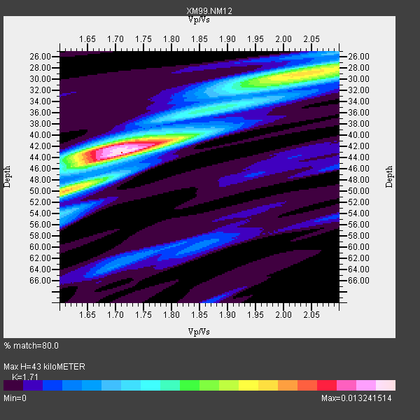
| Thickness Estimate: | 43 km |
| Thickness StdDev: | 6.8 km |
| Vp/Vs Estimate: | 1.71 |
| Vp/Vs StdDev: | 0.15 |
| Vs Estimate: | 3.644 km/s |
| Poisson's Ratio: | 0.24 |
| Peak Value: | 0.01 |
| Assumed Vp: | 6.232 km/s |
| Ps Weight: | 0.33333334 |
| PpPs Weight: | 0.33333334 |
| PsPs Weight: | 0.33333328 |
| Residual Complexity: | 0.685 |
| Nearby stations H: | +- |
| (2.0 deg) Vp/Vs: | +- |
6 with match > 90% ( 33.333332 %) and 16 with match > 80% ( 88.888885 %) out of 18.
Download stack as xyz text file.
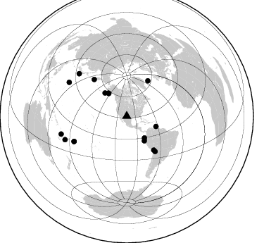
Azimuth Distribution of Events:
Prior Results for this Station
| Study | Thickness | Vp/Vs | Vp | Vs | Poissons Ratio | Extra |
| EARS | 43 km | 1.71 | 6.232 km/s | 3.644 km/s | 0.24 | |
| Crust2.0 | 38 km | 1.76 | 6.232 km/s | 3.534 km/s | 0.26 | P2,orogen/38km, Alps and Foreland, 2 km seds. |
| Wilson | 42 km | 1.73 | 6.26 km/s | 3.618 km/s | 0.25 | |
| Global Maxima | 43 km | 1.71 | 6.232 km/s | 3.644 km/s | 0.24 | amp=0.013241514 |
| Local Maxima 1 | 42 km | 1.69 | 6.232 km/s | 3.682 km/s | 0.23 | amp=0.009037124 |
| Local Maxima 2 | 29 km | 2.04 | 6.232 km/s | 3.062 km/s | 0.34 | amp=0.00874539 |
| Local Maxima 3 | 49 km | 1.63 | 6.232 km/s | 3.823 km/s | 0.20 | amp=0.0044556917 |
| Local Maxima 4 | 31 km | 1.97 | 6.232 km/s | 3.167 km/s | 0.33 | amp=0.0038398071 |
| Predicted Arrivals for vertical incidence (zero ray parameter) | |
| Ps | 4.90 SECOND |
| PpPs | 18.70 SECOND |
| PsPs/PpSs | 23.60 SECOND |
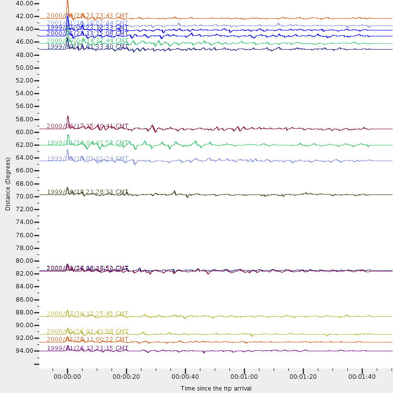
Events Processed for this Station
Download zip of receiver functions as SAC
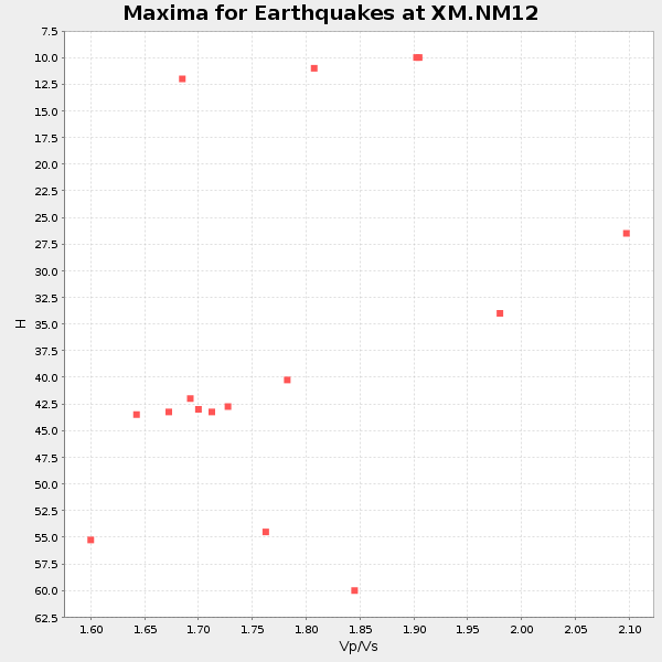
Plot maxima for each earthquake.
Events Used in the Stack
(16 events)| Radial Match | Distance | Baz | FERegion | Time | Lat/Lon | Depth | Magnitude |
| 98.48489 | 95.0 deg | 300.334 deg | Volcano Islands, Japan Region | 2000/03/28 11:00:22 GMT | (22.3, 143.7) | 126 km | 6.8 MB, 7.6 MS, 7.6 MW, 7.6 MW |
| 97.719475 | 41.8 deg | 321.561 deg | Kodiak Island Region, Alaska | 1999/12/06 23:12:33 GMT | (57.4, -154.5) | 66 km | 6.8 MB, 7.0 MW, 7.0 ML |
| 96.33817 | 39.8 deg | 140.637 deg | Near Coast Of Ecuador | 2000/09/28 23:23:43 GMT | (-0.2, -80.6) | 23 km | 5.8 MB, 6.0 MS, 6.6 MW, 6.4 MW |
| 96.037056 | 44.1 deg | 109.368 deg | Windward Islands | 2000/10/04 14:37:44 GMT | (11.1, -62.6) | 110 km | 5.6 MB, 5.4 MS, 6.1 MW, 5.9 MD |
| 92.7138 | 82.8 deg | 244.433 deg | Tonga Islands | 2000/09/26 06:17:52 GMT | (-17.2, -173.9) | 56 km | 6.1 MB, 6.1 MS, 6.4 MW, 6.1 ME |
| 90.84118 | 96.5 deg | 254.744 deg | Vanuatu Islands | 1999/11/26 13:21:15 GMT | (-16.4, 168.2) | 33 km | 6.4 MB, 7.3 MS, 7.5 MW, 7.3 MW |
| 85.9135 | 42.8 deg | 144.31 deg | Near Coast Of Northern Peru | 2000/05/22 13:15:08 GMT | (-4.1, -81.1) | 33 km | 5.3 MB, 5.4 MS, 5.8 MW, 5.8 MW |
| 85.788216 | 45.0 deg | 316.676 deg | Alaska Peninsula | 1999/10/13 01:33:40 GMT | (54.7, -161.2) | 30 km | 6.0 MB, 6.2 MS, 6.5 MW, 6.0 ML |
| 83.938095 | 69.8 deg | 318.42 deg | Near East Coast Of Kamchatka | 1999/09/18 21:28:33 GMT | (51.2, 157.6) | 60 km | 5.9 MB, 5.6 MS, 6.2 MW, 6.0 MW |
| 83.65618 | 61.4 deg | 141.426 deg | Northern Chile | 1999/11/30 04:01:53 GMT | (-18.9, -69.2) | 128 km | 6.2 MB, 6.6 MW, 6.5 MW |
| 83.45934 | 41.0 deg | 321.339 deg | Kodiak Island Region, Alaska | 2001/01/10 16:02:44 GMT | (57.1, -153.2) | 33 km | 6.2 MB, 6.8 MS, 7.1 MW, 6.8 ML |
| 82.77967 | 82.9 deg | 244.402 deg | Tonga Islands | 2000/01/26 13:26:50 GMT | (-17.3, -174.0) | 33 km | 5.9 MB, 6.0 MS, 6.4 MW, 6.3 MW |
| 82.061844 | 93.6 deg | 249.248 deg | Vanuatu Islands Region | 2000/02/25 01:43:58 GMT | (-19.5, 173.8) | 33 km | 6.1 MB, 7.1 MS, 7.1 MW, 7.0 MW |
| 81.33214 | 58.6 deg | 30.944 deg | Iceland | 2000/06/17 15:40:41 GMT | (64.0, -20.5) | 10 km | 5.7 MB, 6.6 MS, 6.8 MW, 6.5 MW |
| 80.96832 | 64.1 deg | 141.043 deg | Southern Bolivia | 1999/09/15 03:01:24 GMT | (-20.9, -67.3) | 218 km | 6.0 MB, 6.4 MW, 6.4 MW |
| 80.88732 | 90.6 deg | 311.681 deg | Southeast Of Honshu, Japan | 2000/07/30 12:25:45 GMT | (33.9, 139.4) | 10 km | 6.0 MB, 6.5 MS, 6.5 MW, 6.5 MW |
Losers
(2 events)| Radial Match | Distance | Baz | FERegion | Time | Lat/Lon | Depth | Magnitude | Reason |
| 98.54411 | 97.9 deg | 249.045 deg | Southeast Of Loyalty Islands | 2001/02/28 13:05:31 GMT | (-22.0, 170.1) | 10 km | 5.8 MB, 6.1 MS, 6.2 MW | |
| 81.350975 | 89.2 deg | 244.191 deg | Fiji Islands Region | 2000/01/15 12:49:45 GMT | (-21.2, -179.3) | 633 km | 5.4 MB, 6.1 MW, 6.0 MW |
