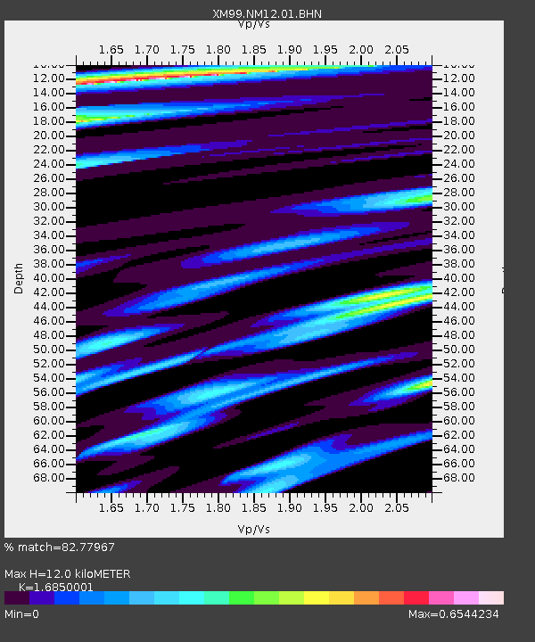
NM12 NewMexico12 - Earthquake Result Viewer
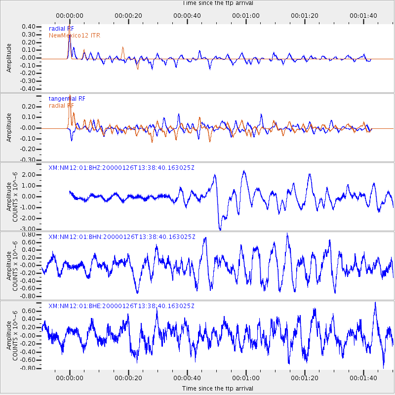
Earthquake location: Tonga Islands
Earthquake latitude/longitude: -17.3/-174.0
Earthquake time(UTC): 2000/01/26 (026) 13:26:50 GMT
Earthquake Depth: 33 km
Earthquake Magnitude: 5.9 MB, 6.0 MS, 6.4 MW, 6.3 MW
Earthquake Catalog/Contributor: WHDF/NEIC
Network: XM Rio Grande Seismic Transect
Station: NM12 NewMexico12
Lat/Lon: 32.68 N/104.51 W
Elevation: 1066 m
Distance: 82.9 deg
Az: 52.749 deg
Baz: 244.402 deg
Ray Param: 0.046525694
Estimated Moho Depth: 12.0 km
Estimated Crust Vp/Vs: 1.69
Assumed Crust Vp: 6.232 km/s
Estimated Crust Vs: 3.698 km/s
Estimated Crust Poisson's Ratio: 0.23
Radial Match: 82.77967 %
Radial Bump: 400
Transverse Match: 55.89958 %
Transverse Bump: 400
SOD ConfigId: 27569
Insert Time: 2010-02-26 17:24:35.492 +0000
GWidth: 2.5
Max Bumps: 400
Tol: 0.001

Signal To Noise

ChannelStoNSTALTA
XM:NM12:01:BHN:20000126T13:38:40.163025Z0.258338665.3350565E-82.0651404E-7
XM:NM12:01:BHE:20000126T13:38:40.163025Z0.96657721.6237391E-71.6798856E-7
XM:NM12:01:BHZ:20000126T13:38:40.163025Z0.68292171.3929218E-72.0396509E-7
Arrivals
Ps1.4 SECOND
PpPs5.0 SECOND
PsPs/PpSs6.4 SECOND