You are here: Home > Network List > XE05 - Sierra Nevada EarthScope Project- EarthScope Flex Array Stations List
> Station YOS03 YOS03 > Earthquake Result Viewer
YOS03 YOS03 - Earthquake Result Viewer
| Earthquake location: |
Sea Of Japan |
| Earthquake latitude/longitude: |
36.8/134.9 |
| Earthquake time(UTC): |
2007/07/16 (197) 14:17:37 GMT |
| Earthquake Depth: |
350 km |
| Earthquake Magnitude: |
6.2 MB, 6.8 MW, 6.8 MW |
| Earthquake Catalog/Contributor: |
WHDF/NEIC |
|
| Network: |
XE Sierra Nevada EarthScope Project- EarthScope Flex Array |
| Station: |
YOS03 YOS03 |
| Lat/Lon: |
37.79 N/119.73 W |
| Elevation: |
2078 m |
|
| Distance: |
78.8 deg |
| Az: |
51.141 deg |
| Baz: |
307.924 deg |
| Ray Param: |
0.048461415 |
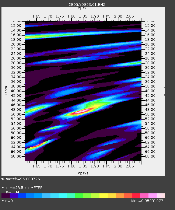
| Estimated Moho Depth: |
48.5 km |
| Estimated Crust Vp/Vs: |
1.84 |
| Assumed Crust Vp: |
6.291 km/s |
| Estimated Crust Vs: |
3.419 km/s |
| Estimated Crust Poisson's Ratio: |
0.29 |
|
| Radial Match: |
96.088776 % |
| Radial Bump: |
400 |
| Transverse Match: |
83.30957 % |
| Transverse Bump: |
400 |
| SOD ConfigId: |
268666 |
| Insert Time: |
2010-03-09 19:42:19.403 +0000 |
| GWidth: |
2.5 |
| Max Bumps: |
400 |
| Tol: |
0.001 |
|

Signal To Noise
| Channel | StoN | STA | LTA |
| XE:YOS03:01:BHZ:20070716T14:28:30.764011Z | 38.497284 | 2.4440487E-6 | 6.348627E-8 |
| XE:YOS03:01:BHN:20070716T14:28:30.764011Z | 16.650122 | 5.226673E-7 | 3.13912E-8 |
| XE:YOS03:01:BHE:20070716T14:28:30.764011Z | 25.978027 | 9.199318E-7 | 3.541192E-8 |
| Arrivals |
| Ps | 6.6 SECOND |
| PpPs | 21 SECOND |
| PsPs/PpSs | 28 SECOND |


