
Station XE YOS03 - YOS03
Network: XE05 - Sierra Nevada EarthScope Project- EarthScope Flex Array
Nearby stations (2 deg radius)
| Station | Name | (Lat, Lon) | Start / End | Elevation |
| YOS03 | YOS03 | (37.79, -119.73) | 2007-07-02 / 2007-12-30 | 2078 m |
| Crust2 Type: | M9,thick extended crust, 0.5 km seds. |
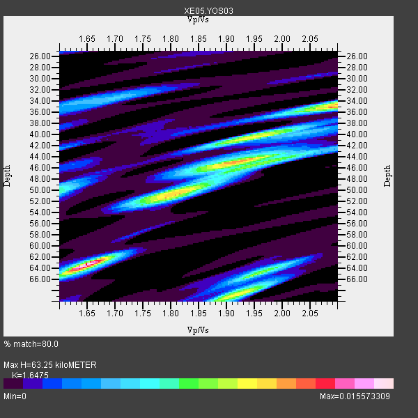
| Thickness Estimate: | 63 km |
| Thickness StdDev: | 13 km |
| Vp/Vs Estimate: | 1.65 |
| Vp/Vs StdDev: | 0.18 |
| Vs Estimate: | 3.819 km/s |
| Poisson's Ratio: | 0.21 |
| Peak Value: | 0.02 |
| Assumed Vp: | 6.291 km/s |
| Ps Weight: | 0.33333334 |
| PpPs Weight: | 0.33333334 |
| PsPs Weight: | 0.33333328 |
| Residual Complexity: | 0.889 |
| Nearby stations H: | +- |
| (2.0 deg) Vp/Vs: | +- |
5 with match > 90% ( 41.666668 %) and 7 with match > 80% ( 58.333332 %) out of 12.
Download stack as xyz text file.
Azimuth Distribution of Events:

Prior Results for this Station
| Study | Thickness | Vp/Vs | Vp | Vs | Poissons Ratio | Extra |
| EARS | 63 km | 1.65 | 6.291 km/s | 3.819 km/s | 0.21 | |
| Crust2.0 | 40 km | 1.78 | 6.291 km/s | 3.539 km/s | 0.27 | M9,thick extended crust, 0.5 km seds. |
| Global Maxima | 63 km | 1.65 | 6.291 km/s | 3.819 km/s | 0.21 | amp=0.015573309 |
| Local Maxima 1 | 35 km | 2.09 | 6.291 km/s | 3.017 km/s | 0.35 | amp=0.011575621 |
| Local Maxima 2 | 44 km | 1.92 | 6.291 km/s | 3.268 km/s | 0.32 | amp=0.011023052 |
| Local Maxima 3 | 68 km | 1.92 | 6.291 km/s | 3.272 km/s | 0.31 | amp=0.010112548 |
| Local Maxima 4 | 51 km | 1.79 | 6.291 km/s | 3.515 km/s | 0.27 | amp=0.008710763 |
| Predicted Arrivals for vertical incidence (zero ray parameter) | |
| Ps | 6.51 SECOND |
| PpPs | 26.62 SECOND |
| PsPs/PpSs | 33.13 SECOND |
Events Processed for this Station
Download zip of receiver functions as SAC
Plot maxima for each earthquake.
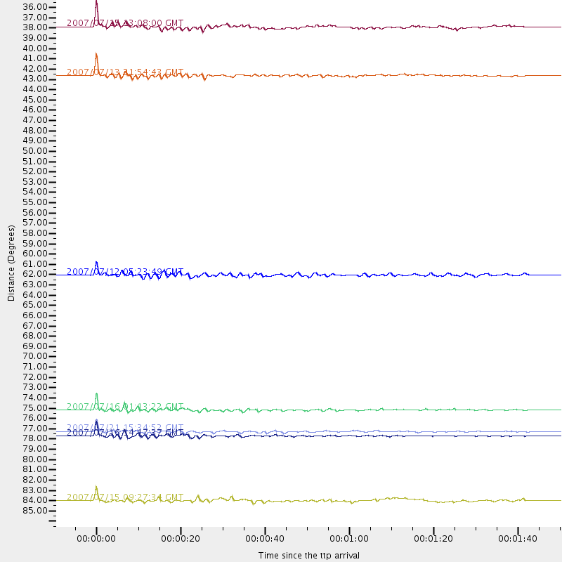
Events Used in the Stack
(7 events)| Radial Match | Distance | Baz | FERegion | Time | Lat/Lon | Depth | Magnitude |
| 97.981674 | 76.0 deg | 306.702 deg | Near West Coast Of Honshu, Japan | 2007/07/16 01:13:22 GMT | (37.5, 138.4) | 12 km | 6.5 MB, 6.4 MS, 6.6 MW, 6.5 MW |
| 96.088776 | 78.8 deg | 307.924 deg | Sea Of Japan | 2007/07/16 14:17:37 GMT | (36.8, 134.9) | 350 km | 6.2 MB, 6.8 MW, 6.8 MW |
| 94.9231 | 36.4 deg | 309.654 deg | Fox Islands, Aleutian Islands | 2007/07/15 13:08:00 GMT | (52.5, -168.0) | 10 km | 5.8 MB, 5.9 MS, 6.1 MW, 6.0 MW |
| 94.62844 | 78.3 deg | 130.039 deg | Jujuy Province, Argentina | 2007/07/21 15:34:52 GMT | (-22.2, -65.8) | 290 km | 5.8 MB, 6.4 MW, 6.3 MW |
| 94.162796 | 41.5 deg | 308.558 deg | Andreanof Islands, Aleutian Is. | 2007/07/13 21:54:43 GMT | (51.8, -176.3) | 35 km | 5.7 MB, 5.6 MS, 6.0 MW, 5.9 MW |
| 84.85238 | 85.4 deg | 246.721 deg | Vanuatu Islands | 2007/07/15 09:27:34 GMT | (-15.4, 168.6) | 8.0 km | 6.0 MB, 5.8 MS, 6.1 MW, 6.0 MW |
| 81.716125 | 62.1 deg | 127.12 deg | Peru-Brazil Border Region | 2007/07/12 05:23:49 GMT | (-7.9, -74.4) | 152 km | 5.9 MB, 6.1 MW, 6.0 MW |
Losers
(5 events)| Radial Match | Distance | Baz | FERegion | Time | Lat/Lon | Depth | Magnitude | Reason |
| 73.572945 | 76.1 deg | 306.665 deg | Near West Coast Of Honshu, Japan | 2007/07/16 06:37:40 GMT | (37.5, 138.5) | 15 km | 5.7 MB, 5.1 MS, 5.7 MW, 5.6 MW | |
| 67.9823 | 64.3 deg | 124.639 deg | Western Brazil | 2007/07/21 13:27:04 GMT | (-8.1, -71.3) | 645 km | 6.2 MB, 6.1 MW, 6.0 MW | |
| 50.04174 | 83.6 deg | 230.117 deg | South Of Fiji Islands | 2007/07/18 23:51:42 GMT | (-26.1, -177.7) | 10 km | 5.5 MS, 5.3 MB, 5.7 MW | |
| 38.64329 | 34.6 deg | 124.675 deg | Guatemala | 2007/07/23 22:30:08 GMT | (14.4, -91.0) | 113 km | 5.5 MW, 5.3 MB, 5.5 MW | |
| 20.883266 | 93.3 deg | 184.981 deg | Pacific-Antarctic Ridge | 2007/07/13 16:33:35 GMT | (-55.6, -128.5) | 10 km | 5.7 MW, 5.2 MS, 5.1 MB, 5.7 MW |
