You are here: Home > Network List > XE05 - Sierra Nevada EarthScope Project- EarthScope Flex Array Stations List
> Station YOS03 YOS03 > Earthquake Result Viewer
YOS03 YOS03 - Earthquake Result Viewer
| Earthquake location: |
Jujuy Province, Argentina |
| Earthquake latitude/longitude: |
-22.2/-65.8 |
| Earthquake time(UTC): |
2007/07/21 (202) 15:34:52 GMT |
| Earthquake Depth: |
290 km |
| Earthquake Magnitude: |
5.8 MB, 6.4 MW, 6.3 MW |
| Earthquake Catalog/Contributor: |
WHDF/NEIC |
|
| Network: |
XE Sierra Nevada EarthScope Project- EarthScope Flex Array |
| Station: |
YOS03 YOS03 |
| Lat/Lon: |
37.79 N/119.73 W |
| Elevation: |
2078 m |
|
| Distance: |
78.3 deg |
| Az: |
319.136 deg |
| Baz: |
130.039 deg |
| Ray Param: |
0.048986048 |
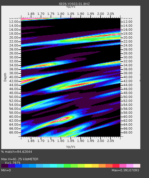
| Estimated Moho Depth: |
61.25 km |
| Estimated Crust Vp/Vs: |
1.80 |
| Assumed Crust Vp: |
6.291 km/s |
| Estimated Crust Vs: |
3.5 km/s |
| Estimated Crust Poisson's Ratio: |
0.28 |
|
| Radial Match: |
94.62844 % |
| Radial Bump: |
319 |
| Transverse Match: |
79.18985 % |
| Transverse Bump: |
400 |
| SOD ConfigId: |
268666 |
| Insert Time: |
2010-03-09 19:42:21.163 +0000 |
| GWidth: |
2.5 |
| Max Bumps: |
400 |
| Tol: |
0.001 |
|

Signal To Noise
| Channel | StoN | STA | LTA |
| XE:YOS03:01:BHZ:20070721T15:45:49.565027Z | 5.673275 | 4.0462942E-7 | 7.132202E-8 |
| XE:YOS03:01:BHN:20070721T15:45:49.565027Z | 1.3480128 | 1.4065697E-7 | 1.0434393E-7 |
| XE:YOS03:01:BHE:20070721T15:45:49.565027Z | 2.4043763 | 9.084138E-8 | 3.7781685E-8 |
| Arrivals |
| Ps | 8.0 SECOND |
| PpPs | 27 SECOND |
| PsPs/PpSs | 34 SECOND |


