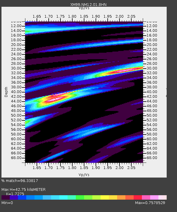
NM12 NewMexico12 - Earthquake Result Viewer

Earthquake location: Near Coast Of Ecuador
Earthquake latitude/longitude: -0.2/-80.6
Earthquake time(UTC): 2000/09/28 (272) 23:23:43 GMT
Earthquake Depth: 23 km
Earthquake Magnitude: 5.8 MB, 6.0 MS, 6.6 MW, 6.4 MW
Earthquake Catalog/Contributor: WHDF/NEIC
Network: XM Rio Grande Seismic Transect
Station: NM12 NewMexico12
Lat/Lon: 32.68 N/104.51 W
Elevation: 1066 m
Distance: 39.8 deg
Az: 327.665 deg
Baz: 140.637 deg
Ray Param: 0.07476816
Estimated Moho Depth: 42.75 km
Estimated Crust Vp/Vs: 1.73
Assumed Crust Vp: 6.232 km/s
Estimated Crust Vs: 3.607 km/s
Estimated Crust Poisson's Ratio: 0.25
Radial Match: 96.33817 %
Radial Bump: 291
Transverse Match: 78.946785 %
Transverse Bump: 400
SOD ConfigId: 27569
Insert Time: 2010-02-26 17:24:36.473 +0000
GWidth: 2.5
Max Bumps: 400
Tol: 0.001

Signal To Noise

ChannelStoNSTALTA
XM:NM12:01:BHN:20000928T23:30:43.502008Z1.94010821.4885534E-77.672528E-8
XM:NM12:01:BHE:20000928T23:30:43.502008Z1.15126071.2807095E-71.112441E-7
XM:NM12:01:BHZ:20000928T23:30:43.502008Z1.97052932.1877112E-71.110215E-7
Arrivals
Ps5.3 SECOND
PpPs17 SECOND
PsPs/PpSs23 SECOND