You are here: Home > Network List > XE05 - Sierra Nevada EarthScope Project- EarthScope Flex Array Stations List
> Station YOS04 YOS04 > Earthquake Result Viewer
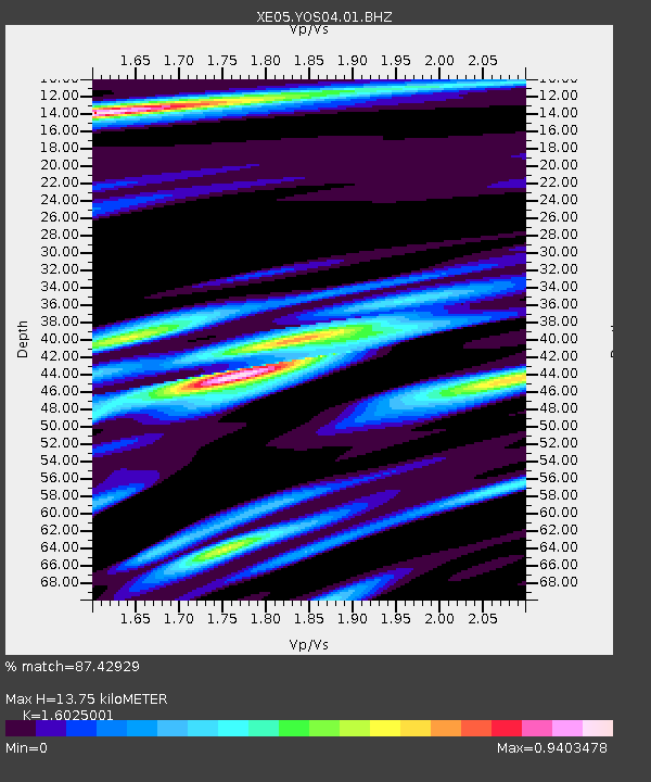
YOS04 YOS04 - Earthquake Result Viewer
| Earthquake location: |
Peru-Brazil Border Region |
| Earthquake latitude/longitude: |
-7.9/-74.4 |
| Earthquake time(UTC): |
2007/07/12 (193) 05:23:49 GMT |
| Earthquake Depth: |
152 km |
| Earthquake Magnitude: |
5.9 MB, 6.1 MW, 6.0 MW |
| Earthquake Catalog/Contributor: |
WHDF/NEIC |
|
| Network: |
XE Sierra Nevada EarthScope Project- EarthScope Flex Array |
| Station: |
YOS04 YOS04 |
| Lat/Lon: |
37.82 N/119.71 W |
| Elevation: |
2210 m |
|
| Distance: |
62.1 deg |
| Az: |
320.416 deg |
| Baz: |
127.152 deg |
| Ray Param: |
0.059987213 |
| Estimated Moho Depth: |
13.75 km |
| Estimated Crust Vp/Vs: |
1.60 |
| Assumed Crust Vp: |
6.291 km/s |
| Estimated Crust Vs: |
3.926 km/s |
| Estimated Crust Poisson's Ratio: |
0.18 |
|
| Radial Match: |
87.42929 % |
| Radial Bump: |
400 |
| Transverse Match: |
79.747765 % |
| Transverse Bump: |
400 |
| SOD ConfigId: |
268666 |
| Insert Time: |
2010-03-09 19:42:31.066 +0000 |
| GWidth: |
2.5 |
| Max Bumps: |
400 |
| Tol: |
0.001 |
|

Signal To Noise
| Channel | StoN | STA | LTA |
| XE:YOS04:01:BHZ:20070712T05:33:23.340Z | 10.287826 | 4.801843E-7 | 4.6675005E-8 |
| XE:YOS04:01:BHN:20070712T05:33:23.340Z | 4.3688374 | 1.6358749E-7 | 3.7444167E-8 |
| XE:YOS04:01:BHE:20070712T05:33:23.340Z | 3.5684094 | 1.5216195E-7 | 4.2641393E-8 |
| Arrivals |
| Ps | 1.4 SECOND |
| PpPs | 5.4 SECOND |
| PsPs/PpSs | 6.8 SECOND |


