
Station XE YOS04 - YOS04
Network: XE05 - Sierra Nevada EarthScope Project- EarthScope Flex Array
Nearby stations (2 deg radius)
| Station | Name | (Lat, Lon) | Start / End | Elevation |
| YOS04 | YOS04 | (37.82, -119.71) | 2007-07-02 / 2007-12-30 | 2210 m |
| Crust2 Type: | M9,thick extended crust, 0.5 km seds. |
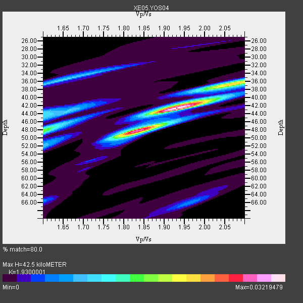
| Thickness Estimate: | 42 km |
| Thickness StdDev: | 3.8 km |
| Vp/Vs Estimate: | 1.93 |
| Vp/Vs StdDev: | 0.14 |
| Vs Estimate: | 3.26 km/s |
| Poisson's Ratio: | 0.32 |
| Peak Value: | 0.03 |
| Assumed Vp: | 6.291 km/s |
| Ps Weight: | 0.33333334 |
| PpPs Weight: | 0.33333334 |
| PsPs Weight: | 0.33333328 |
| Residual Complexity: | 0.547 |
| Nearby stations H: | +- |
| (2.0 deg) Vp/Vs: | +- |
5 with match > 90% ( 31.25 %) and 6 with match > 80% ( 37.5 %) out of 16.
Download stack as xyz text file.
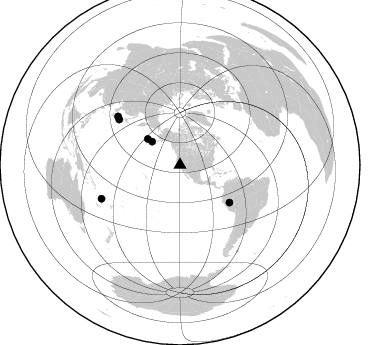
Azimuth Distribution of Events:
Prior Results for this Station
| Study | Thickness | Vp/Vs | Vp | Vs | Poissons Ratio | Extra |
| EARS | 42 km | 1.93 | 6.291 km/s | 3.26 km/s | 0.32 | |
| Crust2.0 | 40 km | 1.78 | 6.291 km/s | 3.539 km/s | 0.27 | M9,thick extended crust, 0.5 km seds. |
| Global Maxima | 42 km | 1.93 | 6.291 km/s | 3.26 km/s | 0.32 | amp=0.03219479 |
| Local Maxima 1 | 48 km | 1.83 | 6.291 km/s | 3.443 km/s | 0.29 | amp=0.021574173 |
| Local Maxima 2 | 36 km | 2.09 | 6.291 km/s | 3.017 km/s | 0.35 | amp=0.01647349 |
| Local Maxima 3 | 48 km | 1.60 | 6.291 km/s | 3.932 km/s | 0.18 | amp=0.010748147 |
| Local Maxima 4 | 36 km | 1.65 | 6.291 km/s | 3.807 km/s | 0.21 | amp=0.010049369 |
| Predicted Arrivals for vertical incidence (zero ray parameter) | |
| Ps | 6.28 SECOND |
| PpPs | 19.79 SECOND |
| PsPs/PpSs | 26.08 SECOND |
Events Processed for this Station
Download zip of receiver functions as SAC
Plot maxima for each earthquake.
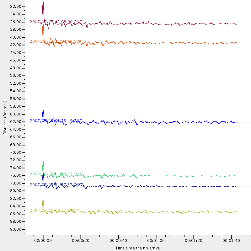
Events Used in the Stack
(6 events)| Radial Match | Distance | Baz | FERegion | Time | Lat/Lon | Depth | Magnitude |
| 97.91094 | 36.4 deg | 309.62 deg | Fox Islands, Aleutian Islands | 2007/07/15 13:08:00 GMT | (52.5, -168.0) | 10 km | 5.8 MB, 5.9 MS, 6.1 MW, 6.0 MW |
| 97.37709 | 76.0 deg | 306.707 deg | Near West Coast Of Honshu, Japan | 2007/07/16 01:13:22 GMT | (37.5, 138.4) | 12 km | 6.5 MB, 6.4 MS, 6.6 MW, 6.5 MW |
| 96.45787 | 85.5 deg | 246.733 deg | Vanuatu Islands | 2007/07/15 09:27:34 GMT | (-15.4, 168.6) | 8.0 km | 6.0 MB, 5.8 MS, 6.1 MW, 6.0 MW |
| 96.39642 | 78.8 deg | 307.93 deg | Sea Of Japan | 2007/07/16 14:17:37 GMT | (36.8, 134.9) | 350 km | 6.2 MB, 6.8 MW, 6.8 MW |
| 96.171616 | 41.4 deg | 308.532 deg | Andreanof Islands, Aleutian Is. | 2007/07/13 21:54:43 GMT | (51.8, -176.3) | 35 km | 5.7 MB, 5.6 MS, 6.0 MW, 5.9 MW |
| 87.42929 | 62.1 deg | 127.152 deg | Peru-Brazil Border Region | 2007/07/12 05:23:49 GMT | (-7.9, -74.4) | 152 km | 5.9 MB, 6.1 MW, 6.0 MW |
Losers
(10 events)| Radial Match | Distance | Baz | FERegion | Time | Lat/Lon | Depth | Magnitude | Reason |
| 79.485054 | 76.0 deg | 306.669 deg | Near West Coast Of Honshu, Japan | 2007/07/16 06:37:40 GMT | (37.5, 138.5) | 15 km | 5.7 MB, 5.1 MS, 5.7 MW, 5.6 MW | |
| 69.23617 | 89.1 deg | 242.773 deg | Loyalty Islands | 2007/07/20 17:23:53 GMT | (-20.8, 168.5) | 10 km | 5.5 MB, 4.9 MS, 5.6 MW, 5.5 MW | |
| 65.30829 | 64.3 deg | 124.669 deg | Western Brazil | 2007/07/21 13:27:04 GMT | (-8.1, -71.3) | 645 km | 6.2 MB, 6.1 MW, 6.0 MW | |
| 64.64616 | 83.7 deg | 230.129 deg | South Of Fiji Islands | 2007/07/18 23:51:42 GMT | (-26.1, -177.7) | 10 km | 5.5 MS, 5.3 MB, 5.7 MW | |
| 61.318638 | 96.0 deg | 306.004 deg | Taiwan | 2007/07/23 13:40:02 GMT | (23.7, 121.6) | 41 km | 5.6 MB, 4.9 MS | |
| 60.90072 | 73.3 deg | 233.067 deg | Samoa Islands Region | 2007/07/06 17:40:49 GMT | (-16.4, -172.6) | 10 km | 5.5 MB, 5.1 MS, 5.7 MW | |
| 51.708305 | 34.6 deg | 124.74 deg | Guatemala | 2007/07/23 22:30:08 GMT | (14.4, -91.0) | 113 km | 5.5 MW, 5.3 MB, 5.5 MW | |
| 49.574192 | 52.7 deg | 112.958 deg | Northern Colombia | 2007/07/16 22:58:23 GMT | (7.2, -72.1) | 30 km | 5.5 MB, 4.5 MS, 5.1 MW, 5.6 ML | |
| 45.847878 | 60.5 deg | 308.193 deg | East Of Kuril Islands | 2007/07/08 18:54:00 GMT | (46.8, 155.5) | 10 km | 5.5 MB, 4.4 MS | |
| 45.061325 | 92.9 deg | 185.57 deg | Pacific-Antarctic Ridge | 2007/07/21 20:40:53 GMT | (-55.1, -129.4) | 10 km | 5.7 MW, 5.2 MS, 5.1 MB |
