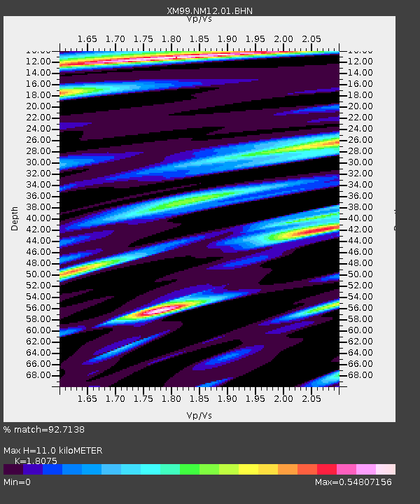
NM12 NewMexico12 - Earthquake Result Viewer
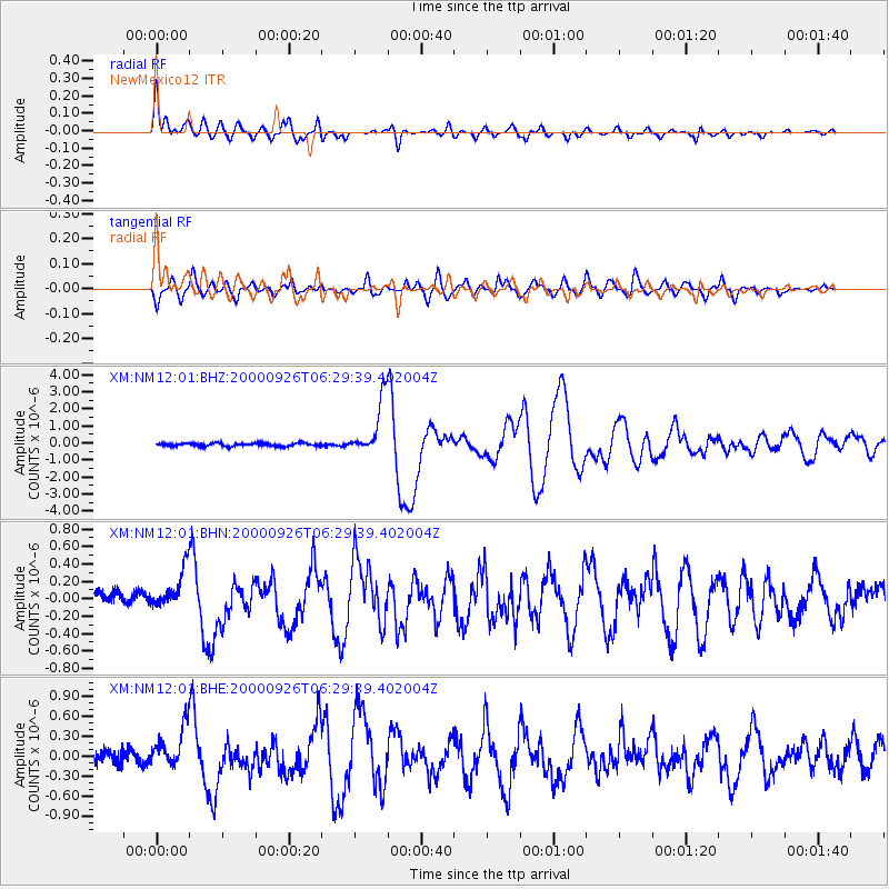
Earthquake location: Tonga Islands
Earthquake latitude/longitude: -17.2/-173.9
Earthquake time(UTC): 2000/09/26 (270) 06:17:52 GMT
Earthquake Depth: 56 km
Earthquake Magnitude: 6.1 MB, 6.1 MS, 6.4 MW, 6.1 ME
Earthquake Catalog/Contributor: WHDF/NEIC
Network: XM Rio Grande Seismic Transect
Station: NM12 NewMexico12
Lat/Lon: 32.68 N/104.51 W
Elevation: 1066 m
Distance: 82.8 deg
Az: 52.73 deg
Baz: 244.433 deg
Ray Param: 0.04654684
Estimated Moho Depth: 11.0 km
Estimated Crust Vp/Vs: 1.81
Assumed Crust Vp: 6.232 km/s
Estimated Crust Vs: 3.448 km/s
Estimated Crust Poisson's Ratio: 0.28
Radial Match: 92.7138 %
Radial Bump: 400
Transverse Match: 85.42502 %
Transverse Bump: 400
SOD ConfigId: 16820
Insert Time: 2010-02-26 17:24:41.294 +0000
GWidth: 2.5
Max Bumps: 400
Tol: 0.001

Signal To Noise

ChannelStoNSTALTA
XM:NM12:01:BHN:20000926T06:29:39.402004Z2.02667572.587373E-71.2766584E-7
XM:NM12:01:BHE:20000926T06:29:39.402004Z3.3161853.3179543E-71.0005335E-7
XM:NM12:01:BHZ:20000926T06:29:39.402004Z17.1634771.5869209E-69.245917E-8
Arrivals
Ps1.5 SECOND
PpPs4.8 SECOND
PsPs/PpSs6.3 SECOND