You are here: Home > Network List > XE05 - Sierra Nevada EarthScope Project- EarthScope Flex Array Stations List
> Station YOS07 YOS07 > Earthquake Result Viewer
YOS07 YOS07 - Earthquake Result Viewer
| Earthquake location: |
Peru-Brazil Border Region |
| Earthquake latitude/longitude: |
-7.9/-74.4 |
| Earthquake time(UTC): |
2007/07/12 (193) 05:23:49 GMT |
| Earthquake Depth: |
152 km |
| Earthquake Magnitude: |
5.9 MB, 6.1 MW, 6.0 MW |
| Earthquake Catalog/Contributor: |
WHDF/NEIC |
|
| Network: |
XE Sierra Nevada EarthScope Project- EarthScope Flex Array |
| Station: |
YOS07 YOS07 |
| Lat/Lon: |
37.81 N/119.58 W |
| Elevation: |
2495 m |
|
| Distance: |
62.0 deg |
| Az: |
320.481 deg |
| Baz: |
127.262 deg |
| Ray Param: |
0.06004228 |
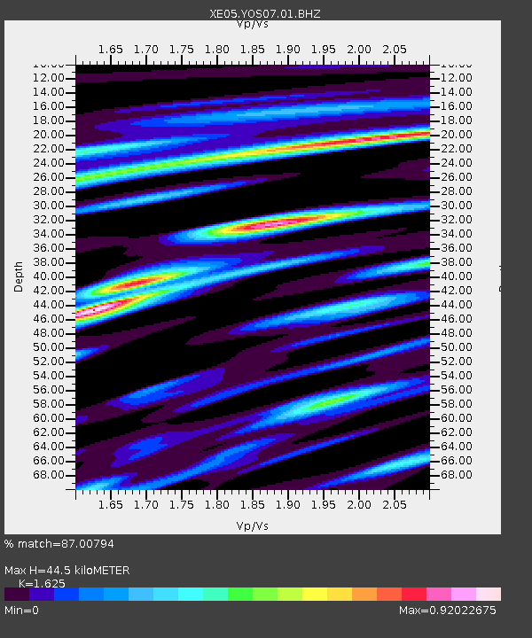
| Estimated Moho Depth: |
44.5 km |
| Estimated Crust Vp/Vs: |
1.62 |
| Assumed Crust Vp: |
6.291 km/s |
| Estimated Crust Vs: |
3.872 km/s |
| Estimated Crust Poisson's Ratio: |
0.20 |
|
| Radial Match: |
87.00794 % |
| Radial Bump: |
400 |
| Transverse Match: |
72.915565 % |
| Transverse Bump: |
400 |
| SOD ConfigId: |
268666 |
| Insert Time: |
2010-03-09 19:43:35.307 +0000 |
| GWidth: |
2.5 |
| Max Bumps: |
400 |
| Tol: |
0.001 |
|

Signal To Noise
| Channel | StoN | STA | LTA |
| XE:YOS07:01:BHZ:20070712T05:33:22.764011Z | 6.8863063 | 4.5781687E-7 | 6.648221E-8 |
| XE:YOS07:01:BHN:20070712T05:33:22.764011Z | 3.0079532 | 1.535459E-7 | 5.104664E-8 |
| XE:YOS07:01:BHE:20070712T05:33:22.764011Z | 3.8015552 | 1.7042761E-7 | 4.4831026E-8 |
| Arrivals |
| Ps | 4.6 SECOND |
| PpPs | 18 SECOND |
| PsPs/PpSs | 22 SECOND |


