
Station XE YOS07 - YOS07
Network: XE05 - Sierra Nevada EarthScope Project- EarthScope Flex Array
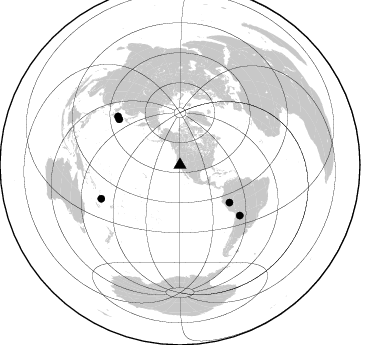
Nearby stations (2 deg radius)
| Station | Name | (Lat, Lon) | Start / End | Elevation |
| YOS07 | YOS07 | (37.81, -119.58) | 2007-07-02 / 2007-12-30 | 2495 m |
| Crust2 Type: | M9,thick extended crust, 0.5 km seds. |
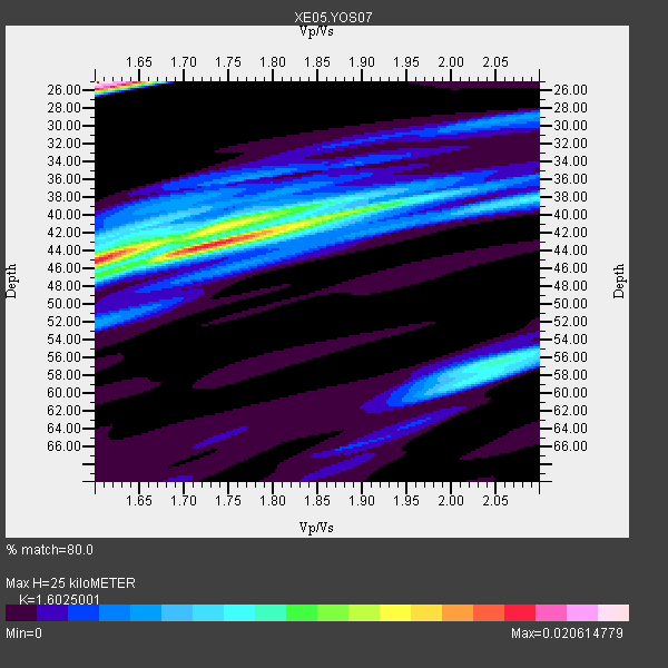
| Thickness Estimate: | 25 km |
| Thickness StdDev: | 8.8 km |
| Vp/Vs Estimate: | 1.60 |
| Vp/Vs StdDev: | 0.13 |
| Vs Estimate: | 3.926 km/s |
| Poisson's Ratio: | 0.18 |
| Peak Value: | 0.02 |
| Assumed Vp: | 6.291 km/s |
| Ps Weight: | 0.33333334 |
| PpPs Weight: | 0.33333334 |
| PsPs Weight: | 0.33333328 |
| Residual Complexity: | 0.954 |
| Nearby stations H: | +- |
| (2.0 deg) Vp/Vs: | +- |
4 with match > 90% ( 28.571428 %) and 5 with match > 80% ( 35.714287 %) out of 14.
Download stack as xyz text file.
Azimuth Distribution of Events:
Prior Results for this Station
| Study | Thickness | Vp/Vs | Vp | Vs | Poissons Ratio | Extra |
| EARS | 25 km | 1.60 | 6.291 km/s | 3.926 km/s | 0.18 | |
| Crust2.0 | 40 km | 1.78 | 6.291 km/s | 3.539 km/s | 0.27 | M9,thick extended crust, 0.5 km seds. |
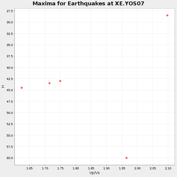
| Global Maxima | 25 km | 1.60 | 6.291 km/s | 3.926 km/s | 0.18 | amp=0.020614779 |
| Local Maxima 1 | 45 km | 1.60 | 6.291 km/s | 3.926 km/s | 0.18 | amp=0.017122779 |
| Local Maxima 2 | 44 km | 1.71 | 6.291 km/s | 3.674 km/s | 0.24 | amp=0.012811704 |
| Local Maxima 3 | 40 km | 1.89 | 6.291 km/s | 3.333 km/s | 0.30 | amp=0.009979499 |
| Local Maxima 4 | 56 km | 2.05 | 6.291 km/s | 3.073 km/s | 0.34 | amp=0.008437781 |
| Predicted Arrivals for vertical incidence (zero ray parameter) | |
| Ps | 2.39 SECOND |
| PpPs | 10.34 SECOND |
| PsPs/PpSs | 12.74 SECOND |
Events Processed for this Station
Download zip of receiver functions as SAC
Plot maxima for each earthquake.
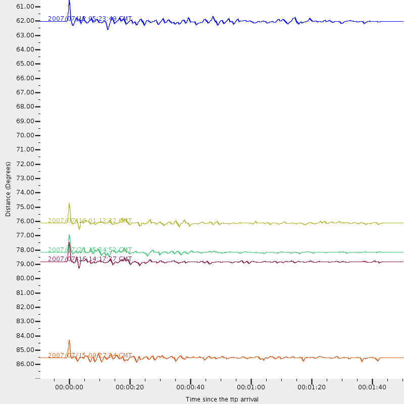
Events Used in the Stack
(5 events)| Radial Match | Distance | Baz | FERegion | Time | Lat/Lon | Depth | Magnitude |
| 95.03598 | 85.6 deg | 246.816 deg | Vanuatu Islands | 2007/07/15 09:27:34 GMT | (-15.4, 168.6) | 8.0 km | 6.0 MB, 5.8 MS, 6.1 MW, 6.0 MW |
| 94.62501 | 78.8 deg | 307.998 deg | Sea Of Japan | 2007/07/16 14:17:37 GMT | (36.8, 134.9) | 350 km | 6.2 MB, 6.8 MW, 6.8 MW |
| 93.92222 | 78.2 deg | 130.152 deg | Jujuy Province, Argentina | 2007/07/21 15:34:52 GMT | (-22.2, -65.8) | 290 km | 5.8 MB, 6.4 MW, 6.3 MW |
| 92.565895 | 76.1 deg | 306.772 deg | Near West Coast Of Honshu, Japan | 2007/07/16 01:13:22 GMT | (37.5, 138.4) | 12 km | 6.5 MB, 6.4 MS, 6.6 MW, 6.5 MW |
| 87.00794 | 62.0 deg | 127.262 deg | Peru-Brazil Border Region | 2007/07/12 05:23:49 GMT | (-7.9, -74.4) | 152 km | 5.9 MB, 6.1 MW, 6.0 MW |
Losers
(9 events)| Radial Match | Distance | Baz | FERegion | Time | Lat/Lon | Depth | Magnitude | Reason |
| 73.23081 | 41.5 deg | 308.544 deg | Andreanof Islands, Aleutian Is. | 2007/07/13 21:54:43 GMT | (51.8, -176.3) | 35 km | 5.7 MB, 5.6 MS, 6.0 MW, 5.9 MW | |
| 69.40009 | 92.9 deg | 185.644 deg | Pacific-Antarctic Ridge | 2007/07/21 20:40:53 GMT | (-55.1, -129.4) | 10 km | 5.7 MW, 5.2 MS, 5.1 MB | |
| 55.689796 | 36.5 deg | 309.617 deg | Fox Islands, Aleutian Islands | 2007/07/15 13:08:00 GMT | (52.5, -168.0) | 10 km | 5.8 MB, 5.9 MS, 6.1 MW, 6.0 MW | |
| 54.25374 | 64.2 deg | 124.775 deg | Western Brazil | 2007/07/21 13:27:04 GMT | (-8.1, -71.3) | 645 km | 6.2 MB, 6.1 MW, 6.0 MW | |
| 53.770042 | 89.2 deg | 242.854 deg | Loyalty Islands | 2007/07/20 17:23:53 GMT | (-20.8, 168.5) | 10 km | 5.5 MB, 4.9 MS, 5.6 MW, 5.5 MW | |
| 43.90204 | 97.2 deg | 343.925 deg | Northern Xinjiang, China | 2007/07/20 10:06:52 GMT | (42.9, 82.4) | 10 km | 5.5 MB, 5.3 MS, 5.6 MW, 5.5 MW | |
| 40.944866 | 52.6 deg | 113.064 deg | Northern Colombia | 2007/07/16 22:58:23 GMT | (7.2, -72.1) | 30 km | 5.5 MB, 4.5 MS, 5.1 MW, 5.6 ML | |
| 30.150818 | 83.9 deg | 230.079 deg | South Of Fiji Islands | 2007/07/18 00:07:35 GMT | (-26.3, -177.7) | 10 km | 5.8 MB, 5.9 MS, 6.1 MW, 6.0 MW | |
| 26.840048 | 34.5 deg | 124.898 deg | Guatemala | 2007/07/23 22:30:08 GMT | (14.4, -91.0) | 113 km | 5.5 MW, 5.3 MB, 5.5 MW |
