You are here: Home > Network List > XM99 - Rio Grande Seismic Transect Stations List
> Station NM12 NewMexico12 > Earthquake Result Viewer
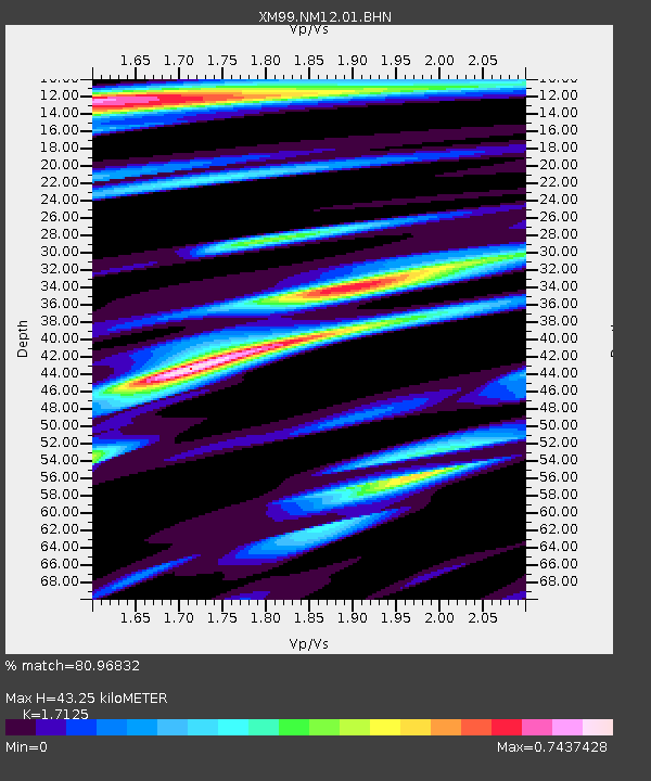
NM12 NewMexico12 - Earthquake Result Viewer
| Earthquake location: |
Southern Bolivia |
| Earthquake latitude/longitude: |
-20.9/-67.3 |
| Earthquake time(UTC): |
1999/09/15 (258) 03:01:24 GMT |
| Earthquake Depth: |
218 km |
| Earthquake Magnitude: |
6.0 MB, 6.4 MW, 6.4 MW |
| Earthquake Catalog/Contributor: |
WHDF/NEIC |
|
| Network: |
XM Rio Grande Seismic Transect |
| Station: |
NM12 NewMexico12 |
| Lat/Lon: |
32.68 N/104.51 W |
| Elevation: |
1066 m |
|
| Distance: |
64.1 deg |
| Az: |
325.444 deg |
| Baz: |
141.043 deg |
| Ray Param: |
0.0584791 |
| Estimated Moho Depth: |
43.25 km |
| Estimated Crust Vp/Vs: |
1.71 |
| Assumed Crust Vp: |
6.232 km/s |
| Estimated Crust Vs: |
3.639 km/s |
| Estimated Crust Poisson's Ratio: |
0.24 |
|
| Radial Match: |
80.96832 % |
| Radial Bump: |
400 |
| Transverse Match: |
66.88222 % |
| Transverse Bump: |
400 |
| SOD ConfigId: |
27569 |
| Insert Time: |
2010-02-26 17:24:45.670 +0000 |
| GWidth: |
2.5 |
| Max Bumps: |
400 |
| Tol: |
0.001 |
|

Signal To Noise
| Channel | StoN | STA | LTA |
| XM:NM12:01:BHN:19990915T03:11:04.246006Z | 2.9213789 | 4.0665168E-7 | 1.3919855E-7 |
| XM:NM12:01:BHE:19990915T03:11:04.246006Z | 4.3625193 | 4.1062233E-7 | 9.412504E-8 |
| XM:NM12:01:BHZ:19990915T03:11:04.246006Z | 9.018069 | 1.5240013E-6 | 1.6899419E-7 |
| Arrivals |
| Ps | 5.2 SECOND |
| PpPs | 18 SECOND |
| PsPs/PpSs | 23 SECOND |


