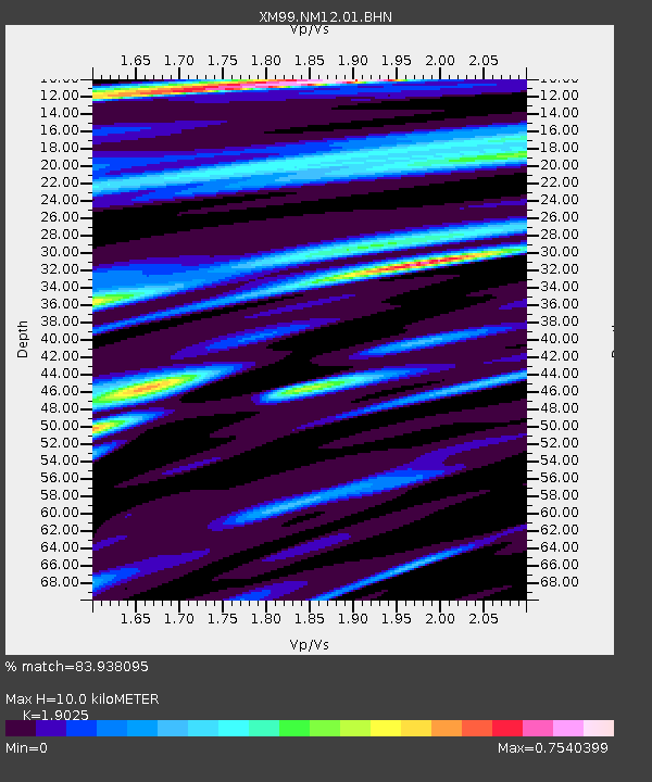
NM12 NewMexico12 - Earthquake Result Viewer
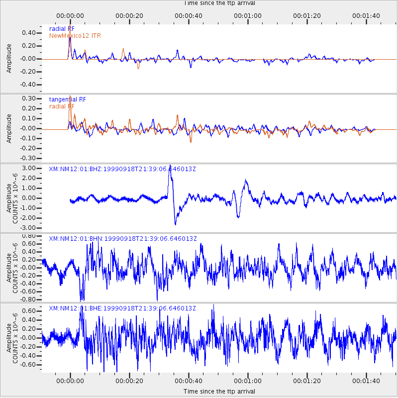
Earthquake location: Near East Coast Of Kamchatka
Earthquake latitude/longitude: 51.2/157.6
Earthquake time(UTC): 1999/09/18 (261) 21:28:33 GMT
Earthquake Depth: 60 km
Earthquake Magnitude: 5.9 MB, 5.6 MS, 6.2 MW, 6.0 MW
Earthquake Catalog/Contributor: WHDF/NEIC
Network: XM Rio Grande Seismic Transect
Station: NM12 NewMexico12
Lat/Lon: 32.68 N/104.51 W
Elevation: 1066 m
Distance: 69.8 deg
Az: 62.837 deg
Baz: 318.42 deg
Ray Param: 0.05524455
Estimated Moho Depth: 10.0 km
Estimated Crust Vp/Vs: 1.90
Assumed Crust Vp: 6.232 km/s
Estimated Crust Vs: 3.275 km/s
Estimated Crust Poisson's Ratio: 0.31
Radial Match: 83.938095 %
Radial Bump: 400
Transverse Match: 69.98902 %
Transverse Bump: 400
SOD ConfigId: 27569
Insert Time: 2010-02-26 17:24:47.721 +0000
GWidth: 2.5
Max Bumps: 400
Tol: 0.001

Signal To Noise

ChannelStoNSTALTA
XM:NM12:01:BHN:19990918T21:39:06.646013Z2.53052543.6632818E-71.4476367E-7
XM:NM12:01:BHE:19990918T21:39:06.646013Z1.78127682.5996874E-71.4594517E-7
XM:NM12:01:BHZ:19990918T21:39:06.646013Z7.17095661.3507457E-61.8836339E-7
Arrivals
Ps1.5 SECOND
PpPs4.5 SECOND
PsPs/PpSs6.0 SECOND