You are here: Home > Network List > XM99 - Rio Grande Seismic Transect Stations List
> Station NM12 NewMexico12 > Earthquake Result Viewer
NM12 NewMexico12 - Earthquake Result Viewer
| Earthquake location: |
Kodiak Island Region, Alaska |
| Earthquake latitude/longitude: |
57.4/-154.5 |
| Earthquake time(UTC): |
1999/12/06 (340) 23:12:33 GMT |
| Earthquake Depth: |
66 km |
| Earthquake Magnitude: |
6.8 MB, 7.0 MW, 7.0 ML |
| Earthquake Catalog/Contributor: |
WHDF/NEIC |
|
| Network: |
XM Rio Grande Seismic Transect |
| Station: |
NM12 NewMexico12 |
| Lat/Lon: |
32.68 N/104.51 W |
| Elevation: |
1066 m |
|
| Distance: |
41.8 deg |
| Az: |
104.348 deg |
| Baz: |
321.561 deg |
| Ray Param: |
0.07335086 |
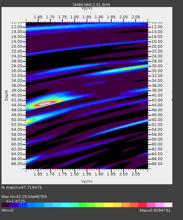
| Estimated Moho Depth: |
43.25 km |
| Estimated Crust Vp/Vs: |
1.67 |
| Assumed Crust Vp: |
6.232 km/s |
| Estimated Crust Vs: |
3.726 km/s |
| Estimated Crust Poisson's Ratio: |
0.22 |
|
| Radial Match: |
97.719475 % |
| Radial Bump: |
323 |
| Transverse Match: |
91.19323 % |
| Transverse Bump: |
400 |
| SOD ConfigId: |
27569 |
| Insert Time: |
2010-02-26 17:24:49.604 +0000 |
| GWidth: |
2.5 |
| Max Bumps: |
400 |
| Tol: |
0.001 |
|

Signal To Noise
| Channel | StoN | STA | LTA |
| XM:NM12:01:BHN:19991206T23:19:46.657Z | 8.484362 | 1.1093748E-6 | 1.3075524E-7 |
| XM:NM12:01:BHE:19991206T23:19:46.657Z | 4.4357376 | 7.2491923E-7 | 1.6342698E-7 |
| XM:NM12:01:BHZ:19991206T23:19:46.657Z | 12.222331 | 3.0069307E-6 | 2.460194E-7 |
| Arrivals |
| Ps | 5.0 SECOND |
| PpPs | 17 SECOND |
| PsPs/PpSs | 22 SECOND |


