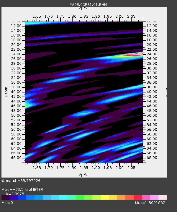
CCPS1 Cactus Peak S1 - Earthquake Result Viewer

Earthquake location: Tonga Islands
Earthquake latitude/longitude: -16.9/-174.2
Earthquake time(UTC): 2000/01/08 (008) 16:47:20 GMT
Earthquake Depth: 183 km
Earthquake Magnitude: 6.5 MB, 6.6 MS, 7.2 MW, 7.0 ME
Earthquake Catalog/Contributor: WHDF/NEIC
Network: YA Coso Passive Short Period Arrays
Station: CCPS1 Cactus Peak S1
Lat/Lon: 36.07 N/117.82 W
Elevation: 1450 m
Distance: 75.0 deg
Az: 44.341 deg
Baz: 235.67 deg
Ray Param: 0.05149925
Estimated Moho Depth: 23.5 km
Estimated Crust Vp/Vs: 2.10
Assumed Crust Vp: 6.279 km/s
Estimated Crust Vs: 2.993 km/s
Estimated Crust Poisson's Ratio: 0.35
Radial Match: 89.797226 %
Radial Bump: 400
Transverse Match: 92.4347 %
Transverse Bump: 400
SOD ConfigId: 16820
Insert Time: 2010-03-09 19:45:58.105 +0000
GWidth: 2.5
Max Bumps: 400
Tol: 0.001

Signal To Noise

ChannelStoNSTALTA
YA:CCPS1:01:BHN:20000108T16:58:10.608015Z12.6668783.0676696E-72.4218041E-8
YA:CCPS1:01:BHE:20000108T16:58:10.608015Z38.7461439.755427E-72.51778E-8
YA:CCPS1:01:BHZ:20000108T16:58:10.608015Z98.056092.6653556E-62.7181947E-8
Arrivals
Ps4.2 SECOND
PpPs11 SECOND
PsPs/PpSs16 SECOND