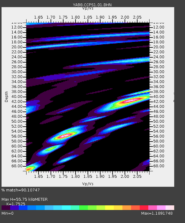
CCPS1 Cactus Peak S1 - Earthquake Result Viewer

Earthquake location: Fiji Islands Region
Earthquake latitude/longitude: -18.8/174.4
Earthquake time(UTC): 2000/01/09 (009) 21:54:40 GMT
Earthquake Depth: 33 km
Earthquake Magnitude: 5.6 MB, 6.4 MS, 6.4 MW, 6.3 MW
Earthquake Catalog/Contributor: WHDF/NEIC
Network: YA Coso Passive Short Period Arrays
Station: CCPS1 Cactus Peak S1
Lat/Lon: 36.07 N/117.82 W
Elevation: 1450 m
Distance: 84.2 deg
Az: 48.946 deg
Baz: 241.839 deg
Ray Param: 0.045637175
Estimated Moho Depth: 55.75 km
Estimated Crust Vp/Vs: 1.75
Assumed Crust Vp: 6.279 km/s
Estimated Crust Vs: 3.583 km/s
Estimated Crust Poisson's Ratio: 0.26
Radial Match: 90.10747 %
Radial Bump: 400
Transverse Match: 83.908195 %
Transverse Bump: 400
SOD ConfigId: 3744
Insert Time: 2010-03-09 19:46:00.396 +0000
GWidth: 2.5
Max Bumps: 400
Tol: 0.001

Signal To Noise

ChannelStoNSTALTA
YA:CCPS1:01:BHN:20000109T22:06:37.107004Z1.28268923.5578918E-82.7737753E-8
YA:CCPS1:01:BHE:20000109T22:06:37.107004Z1.22388153.6914983E-83.016222E-8
YA:CCPS1:01:BHZ:20000109T22:06:37.107004Z2.8706198.0968704E-82.8206006E-8
Arrivals
Ps6.8 SECOND
PpPs24 SECOND
PsPs/PpSs31 SECOND