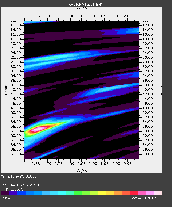
NM15 NewMexico15 - Earthquake Result Viewer

Earthquake location: Near Coast Of Northern Peru
Earthquake latitude/longitude: -4.1/-81.1
Earthquake time(UTC): 2000/05/22 (143) 13:15:08 GMT
Earthquake Depth: 33 km
Earthquake Magnitude: 5.3 MB, 5.4 MS, 5.8 MW, 5.8 MW
Earthquake Catalog/Contributor: WHDF/NEIC
Network: XM Rio Grande Seismic Transect
Station: NM15 NewMexico15
Lat/Lon: 33.01 N/104.91 W
Elevation: 1342 m
Distance: 43.3 deg
Az: 330.329 deg
Baz: 144.007 deg
Ray Param: 0.07259961
Estimated Moho Depth: 56.75 km
Estimated Crust Vp/Vs: 1.66
Assumed Crust Vp: 6.232 km/s
Estimated Crust Vs: 3.76 km/s
Estimated Crust Poisson's Ratio: 0.21
Radial Match: 85.61921 %
Radial Bump: 392
Transverse Match: 67.79599 %
Transverse Bump: 400
SOD ConfigId: 16820
Insert Time: 2010-02-26 17:24:54.281 +0000
GWidth: 2.5
Max Bumps: 400
Tol: 0.001

Signal To Noise

ChannelStoNSTALTA
XM:NM15:01:BHN:20000522T13:22:36.772012Z1.29422836.470283E-84.9993364E-8
XM:NM15:01:BHE:20000522T13:22:36.772012Z1.04051631.2244752E-71.1767958E-7
XM:NM15:01:BHZ:20000522T13:22:36.772012Z1.0229921.0627931E-71.0389065E-7
Arrivals
Ps6.4 SECOND
PpPs23 SECOND
PsPs/PpSs29 SECOND