You are here: Home > Network List > XM99 - Rio Grande Seismic Transect Stations List
> Station NM15 NewMexico15 > Earthquake Result Viewer
NM15 NewMexico15 - Earthquake Result Viewer
| Earthquake location: |
Fiji Islands Region |
| Earthquake latitude/longitude: |
-21.2/-179.3 |
| Earthquake time(UTC): |
2000/01/15 (015) 12:49:45 GMT |
| Earthquake Depth: |
633 km |
| Earthquake Magnitude: |
5.4 MB, 6.1 MW, 6.0 MW |
| Earthquake Catalog/Contributor: |
WHDF/NEIC |
|
| Network: |
XM Rio Grande Seismic Transect |
| Station: |
NM15 NewMexico15 |
| Lat/Lon: |
33.01 N/104.91 W |
| Elevation: |
1342 m |
|
| Distance: |
89.1 deg |
| Az: |
54.012 deg |
| Baz: |
243.968 deg |
| Ray Param: |
0.041591894 |
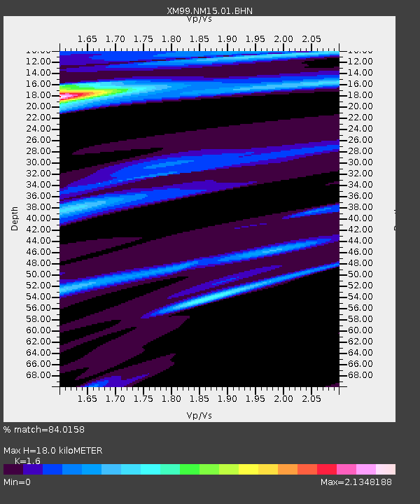
| Estimated Moho Depth: |
18.0 km |
| Estimated Crust Vp/Vs: |
1.60 |
| Assumed Crust Vp: |
6.232 km/s |
| Estimated Crust Vs: |
3.895 km/s |
| Estimated Crust Poisson's Ratio: |
0.18 |
|
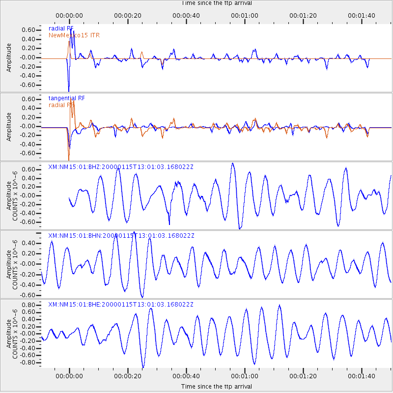
| Radial Match: |
84.0158 % |
| Radial Bump: |
400 |
| Transverse Match: |
42.582733 % |
| Transverse Bump: |
400 |
| SOD ConfigId: |
16820 |
| Insert Time: |
2010-02-26 17:24:56.134 +0000 |
| GWidth: |
2.5 |
| Max Bumps: |
400 |
| Tol: |
0.001 |
|
Signal To Noise
| Channel | StoN | STA | LTA |
| XM:NM15:01:BHN:20000115T13:01:03.168022Z | 0.61137706 | 1.5502117E-7 | 2.5356064E-7 |
| XM:NM15:01:BHE:20000115T13:01:03.168022Z | 0.6568866 | 1.3704575E-7 | 2.0862925E-7 |
| XM:NM15:01:BHZ:20000115T13:01:03.168022Z | 0.79518986 | 2.5945374E-7 | 3.2627898E-7 |
| Arrivals |
| Ps | 1.8 SECOND |
| PpPs | 7.4 SECOND |
| PsPs/PpSs | 9.1 SECOND |


