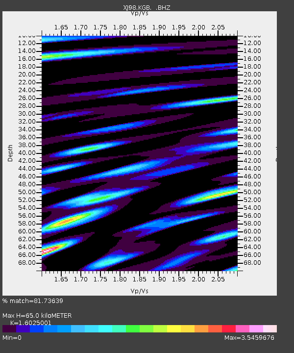
KGB Krutoberegovo - Earthquake Result Viewer

Earthquake location: Central Mexico
Earthquake latitude/longitude: 18.4/-97.4
Earthquake time(UTC): 1999/06/15 (166) 20:42:05 GMT
Earthquake Depth: 70 km
Earthquake Magnitude: 6.4 MB, 6.5 MS, 7.0 MW, 6.7 ME
Earthquake Catalog/Contributor: WHDF/NEIC
Network: XJ Side Edge of Kamchatka Subduction Zone
Station: KGB Krutoberegovo
Lat/Lon: 56.26 N/162.71 E
Elevation: 13 m
Distance: 80.2 deg
Az: 326.091 deg
Baz: 71.68 deg
Ray Param: 0.048269376
Estimated Moho Depth: 65.0 km
Estimated Crust Vp/Vs: 1.60
Assumed Crust Vp: 6.183 km/s
Estimated Crust Vs: 3.858 km/s
Estimated Crust Poisson's Ratio: 0.18
Radial Match: 81.73639 %
Radial Bump: 400
Transverse Match: 75.16789 %
Transverse Bump: 400
SOD ConfigId: 4480
Insert Time: 2010-03-09 19:51:00.750 +0000
GWidth: 2.5
Max Bumps: 400
Tol: 0.001

Signal To Noise

ChannelStoNSTALTA
XJ:KGB: :BHZ:19990615T20:53:37.929023Z6.7719693.0260856E-64.468546E-7
XJ:KGB: :BHN:19990615T20:53:37.929023Z0.639795668.337752E-71.3031897E-6
XJ:KGB: :BHE:19990615T20:53:37.929023Z1.01408481.7132668E-61.6894709E-6
Arrivals
Ps6.5 SECOND
PpPs27 SECOND
PsPs/PpSs33 SECOND