
Station XJ KGB - Krutoberegovo
Network: XJ98 - Side Edge of Kamchatka Subduction Zone
Nearby stations (2 deg radius)
| Station | Name | (Lat, Lon) | Start / End | Elevation |
| KGB | Krutoberegovo | (56.26, 162.71) | 1998-09-05 / 1999-12-31 | 13 m |
| Crust2 Type: | S1,continental slope, margin, transition 1 km seds. |
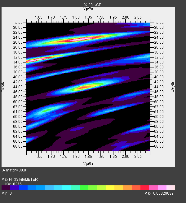
| Thickness Estimate: | 33 km |
| Thickness StdDev: | 10 km |
| Vp/Vs Estimate: | 1.64 |
| Vp/Vs StdDev: | 0.13 |
| Vs Estimate: | 3.776 km/s |
| Poisson's Ratio: | 0.20 |
| Peak Value: | 0.06 |
| Assumed Vp: | 6.183 km/s |
| Ps Weight: | 0.33333334 |
| PpPs Weight: | 0.33333334 |
| PsPs Weight: | 0.33333328 |
| Residual Complexity: | 0.881 |
| Nearby stations H: | +- |
| (2.0 deg) Vp/Vs: | +- |
0 with match > 90% ( 0.0 %) and 6 with match > 80% ( 20.0 %) out of 30.
Download stack as xyz text file.
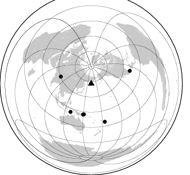
Azimuth Distribution of Events:
Prior Results for this Station
| Study | Thickness | Vp/Vs | Vp | Vs | Poissons Ratio | Extra |
| EARS | 33 km | 1.64 | 6.183 km/s | 3.776 km/s | 0.20 | |
| Crust2.0 | 23 km | 1.81 | 6.183 km/s | 3.422 km/s | 0.28 | S1,continental slope, margin, transition 1 km seds. |
| Global Maxima | 33 km | 1.64 | 6.183 km/s | 3.776 km/s | 0.20 | amp=0.06329039 |
| Local Maxima 1 | 25 km | 1.81 | 6.183 km/s | 3.416 km/s | 0.28 | amp=0.061452415 |
| Local Maxima 2 | 44 km | 1.82 | 6.183 km/s | 3.392 km/s | 0.28 | amp=0.04888366 |
| Local Maxima 3 | 32 km | 2.10 | 6.183 km/s | 2.948 km/s | 0.35 | amp=0.025838178 |
| Local Maxima 4 | 54 km | 1.68 | 6.183 km/s | 3.691 km/s | 0.22 | amp=0.02252694 |
| Predicted Arrivals for vertical incidence (zero ray parameter) | |
| Ps | 3.40 SECOND |
| PpPs | 14.08 SECOND |
| PsPs/PpSs | 17.48 SECOND |
Events Processed for this Station
Download zip of receiver functions as SAC
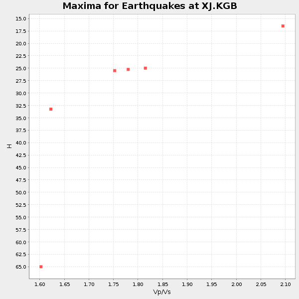
Plot maxima for each earthquake.
Events Used in the Stack
(6 events)| Radial Match | Distance | Baz | FERegion | Time | Lat/Lon | Depth | Magnitude |
| 87.79468 | 62.6 deg | 194.772 deg | New Britain Region, P.N.G. | 1999/04/05 11:08:04 GMT | (-5.6, 149.6) | 150 km | 6.2 MB, 7.0 MS, 7.4 MW, 7.3 ME |
| 86.28506 | 62.0 deg | 193.376 deg | New Britain Region, P.N.G. | 1999/05/10 20:33:02 GMT | (-5.2, 150.9) | 138 km | 6.5 MB, 6.8 MS, 7.1 MW, 6.5 MB |
| 84.18393 | 79.4 deg | 160.3 deg | Fiji Islands Region | 1999/04/13 10:38:48 GMT | (-21.4, -176.5) | 164 km | 6.4 MB, 6.8 MW, 6.8 MW |
| 82.84463 | 61.6 deg | 283.037 deg | Western Xizang-India Border Reg. | 1999/03/28 19:05:11 GMT | (30.5, 79.4) | 15 km | 6.4 MB, 6.6 MS, 6.6 MW, 6.5 ME |
| 81.73639 | 80.2 deg | 71.68 deg | Central Mexico | 1999/06/15 20:42:05 GMT | (18.4, -97.4) | 70 km | 6.4 MB, 6.5 MS, 7.0 MW, 6.7 ME |
| 81.13549 | 68.8 deg | 216.194 deg | Banda Sea | 1998/11/09 05:30:14 GMT | (-7.0, 129.0) | 33 km | 6.1 MB, 6.7 UNKNOWN, 6.6 ME |
Losers
(24 events)| Radial Match | Distance | Baz | FERegion | Time | Lat/Lon | Depth | Magnitude | Reason |
| 82.836235 | 62.0 deg | 207.971 deg | Irian Jaya, Indonesia | 1999/05/16 15:25:53 GMT | (-2.6, 138.2) | 59 km | 6.1 MB, 6.2 MS, 6.4 MW, 6.4 ME | |
| 81.334656 | 68.9 deg | 175.834 deg | Santa Cruz Islands | 1999/02/06 21:47:59 GMT | (-12.9, 166.7) | 90 km | 6.3 MB, 7.3 MS, 7.4 MW, 7.0 ME | |
| 78.60059 | 87.5 deg | 68.735 deg | Near Coast Of Guatemala | 1999/06/06 07:08:05 GMT | (13.9, -90.8) | 33 km | 5.5 MB, 5.9 MS, 6.3 MW, 5.8 MD | |
| 78.40027 | 64.6 deg | 225.681 deg | Minahassa Peninsula, Sulawesi | 1998/09/21 06:52:41 GMT | (0.3, 122.5) | 147 km | 6.1 MB, 6.0 UNKNOWN, 5.9 MW | |
| 77.860565 | 61.7 deg | 191.136 deg | New Britain Region, P.N.G. | 1999/05/17 10:07:56 GMT | (-5.2, 152.9) | 27 km | 5.5 MB, 6.9 MS, 6.7 MW, 6.0 ME | |
| 74.91052 | 89.2 deg | 164.549 deg | Kermadec Islands Region | 1999/04/20 19:04:08 GMT | (-31.9, -179.0) | 96 km | 6.2 MB, 6.5 MW, 6.5 MW | |
| 71.56727 | 60.1 deg | 228.586 deg | Celebes Sea | 1999/03/04 08:52:01 GMT | (5.4, 121.9) | 33 km | 6.4 MB, 6.5 MS, 7.1 MW, 7.1 MW | |
| 70.66246 | 61.4 deg | 191.628 deg | New Britain Region, P.N.G. | 1999/05/16 00:51:20 GMT | (-4.8, 152.5) | 74 km | 6.0 MB, 7.0 MS, 7.1 MW, 6.3 ME | |
| 70.22945 | 76.4 deg | 231.596 deg | Java, Indonesia | 1998/09/28 13:34:30 GMT | (-8.2, 112.4) | 152 km | 6.4 MB, 6.5 UNKNOWN, 6.5 MW | |
| 69.74537 | 63.1 deg | 195.891 deg | New Britain Region, P.N.G. | 1999/04/11 16:50:39 GMT | (-6.0, 148.5) | 58 km | 5.6 MB, 5.7 MS, 6.1 MW, 6.0 MW | |
| 68.56509 | 45.1 deg | 204.516 deg | Mariana Islands | 1999/04/23 18:56:26 GMT | (13.1, 145.1) | 52 km | 5.5 MB, 5.5 MS, 5.9 MW, 5.7 MW | |
| 68.42683 | 76.0 deg | 174.684 deg | Vanuatu Islands | 1999/04/02 17:05:47 GMT | (-19.9, 168.2) | 10 km | 6.1 MB, 6.0 MS, 6.2 MW, 6.2 MW | |
| 66.460266 | 83.3 deg | 166.022 deg | South Of Fiji Islands | 1999/04/09 12:16:01 GMT | (-26.4, 178.2) | 621 km | 5.5 MB, 6.2 MW, 6.1 MW | |
| 66.06595 | 63.9 deg | 197.428 deg | Eastern New Guinea Reg., P.N.G. | 1999/04/06 08:22:14 GMT | (-6.5, 147.0) | 33 km | 5.8 MB, 6.3 MS, 6.3 MW, 6.2 MW | |
| 64.555405 | 61.6 deg | 191.279 deg | New Britain Region, P.N.G. | 1999/05/18 06:16:10 GMT | (-5.0, 152.8) | 33 km | 5.8 MS, 5.3 MB, 5.9 MW, 5.8 MW | |
| 56.933098 | 37.3 deg | 236.682 deg | Northwest Of Ryukyu Islands | 1998/10/03 11:15:42 GMT | (28.5, 127.6) | 227 km | 5.6 MB, 6.1 UNKNOWN, 6.1 MW | |
| 55.35254 | 35.4 deg | 232.511 deg | Southeast Of Ryukyu Islands | 1999/04/29 07:46:08 GMT | (28.9, 131.1) | 33 km | 5.8 MB, 5.5 MS, 5.9 MW, 5.9 MW | |
| 54.98156 | 64.3 deg | 224.555 deg | Minahassa Peninsula, Sulawesi | 1999/06/02 00:23:19 GMT | (0.1, 123.5) | 161 km | 5.8 MB, 5.6 MW | |
| 54.267097 | 45.3 deg | 206.072 deg | Mariana Islands | 1998/09/08 09:10:03 GMT | (13.3, 144.0) | 141 km | 5.8 MB, 5.8 UNKNOWN, 5.8 MW | |
| 53.907337 | 73.6 deg | 222.799 deg | Savu Sea | 1998/11/08 07:25:48 GMT | (-9.1, 121.4) | 33 km | 6.0 MB, 5.9 MS, 6.4 UNKNOWN, 5.7 ME | |
| 53.211735 | 39.2 deg | 206.529 deg | Mariana Islands | 1998/10/18 08:33:54 GMT | (19.3, 145.3) | 152 km | 5.5 UNKNOWN, 5.4 MB, 5.5 MW | |
| 53.03421 | 86.6 deg | 69.53 deg | Guatemala | 1999/05/08 22:12:45 GMT | (14.2, -91.9) | 39 km | 5.3 MB, 5.7 MS, 6.3 MW, 5.4 MD | |
| 51.78606 | 59.1 deg | 226.681 deg | Mindanao, Philippines | 1999/05/18 19:52:59 GMT | (5.6, 123.9) | 33 km | 5.8 MB, 5.6 MS, 5.8 MW, 5.8 MW | |
| 44.9261 | 78.5 deg | 162.7 deg | Fiji Islands Region | 1998/10/11 12:04:54 GMT | (-21.0, -179.1) | 624 km | 5.9 UNKNOWN, 5.4 MB, 5.9 MW |
