You are here: Home > Network List > XM99 - Rio Grande Seismic Transect Stations List
> Station NM15 NewMexico15 > Earthquake Result Viewer
NM15 NewMexico15 - Earthquake Result Viewer
| Earthquake location: |
Fiji Islands Region |
| Earthquake latitude/longitude: |
-18.1/-176.9 |
| Earthquake time(UTC): |
2001/04/28 (118) 04:49:53 GMT |
| Earthquake Depth: |
352 km |
| Earthquake Magnitude: |
6.2 MB, 6.8 MW, 6.8 MW |
| Earthquake Catalog/Contributor: |
WHDF/NEIC |
|
| Network: |
XM Rio Grande Seismic Transect |
| Station: |
NM15 NewMexico15 |
| Lat/Lon: |
33.01 N/104.91 W |
| Elevation: |
1342 m |
|
| Distance: |
85.4 deg |
| Az: |
53.297 deg |
| Baz: |
245.2 deg |
| Ray Param: |
0.043861564 |
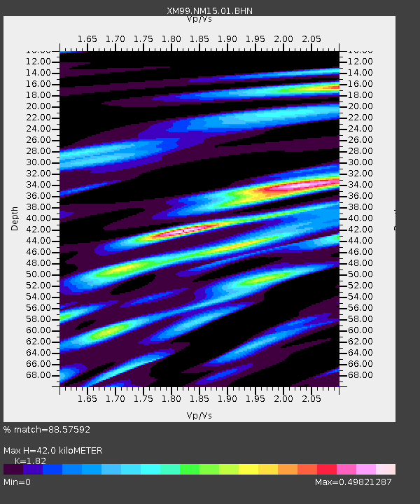
| Estimated Moho Depth: |
42.0 km |
| Estimated Crust Vp/Vs: |
1.82 |
| Assumed Crust Vp: |
6.232 km/s |
| Estimated Crust Vs: |
3.424 km/s |
| Estimated Crust Poisson's Ratio: |
0.28 |
|
| Radial Match: |
88.57592 % |
| Radial Bump: |
387 |
| Transverse Match: |
80.595795 % |
| Transverse Bump: |
312 |
| SOD ConfigId: |
4714 |
| Insert Time: |
2010-02-26 17:25:13.689 +0000 |
| GWidth: |
2.5 |
| Max Bumps: |
400 |
| Tol: |
0.001 |
|

Signal To Noise
| Channel | StoN | STA | LTA |
| XM:NM15:01:BHN:20010428T05:01:20.97303Z | 2.2845123 | 1.4274043E-7 | 6.2481796E-8 |
| XM:NM15:01:BHE:20010428T05:01:20.97303Z | 2.5889769 | 2.1064582E-7 | 8.136257E-8 |
| XM:NM15:01:BHZ:20010428T05:01:20.97303Z | 7.2121706 | 7.26495E-7 | 1.0073181E-7 |
| Arrivals |
| Ps | 5.6 SECOND |
| PpPs | 19 SECOND |
| PsPs/PpSs | 24 SECOND |


