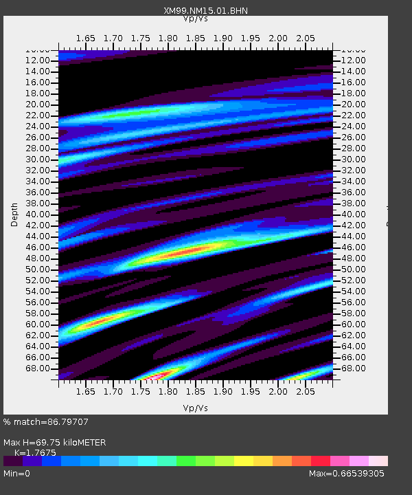
NM15 NewMexico15 - Earthquake Result Viewer

Earthquake location: Alaska Peninsula
Earthquake latitude/longitude: 54.7/-161.2
Earthquake time(UTC): 1999/10/13 (286) 01:33:40 GMT
Earthquake Depth: 30 km
Earthquake Magnitude: 6.0 MB, 6.2 MS, 6.5 MW, 6.0 ML
Earthquake Catalog/Contributor: WHDF/NEIC
Network: XM Rio Grande Seismic Transect
Station: NM15 NewMexico15
Lat/Lon: 33.01 N/104.91 W
Elevation: 1342 m
Distance: 44.6 deg
Az: 95.275 deg
Baz: 316.477 deg
Ray Param: 0.07177872
Estimated Moho Depth: 69.75 km
Estimated Crust Vp/Vs: 1.77
Assumed Crust Vp: 6.232 km/s
Estimated Crust Vs: 3.526 km/s
Estimated Crust Poisson's Ratio: 0.26
Radial Match: 86.79707 %
Radial Bump: 400
Transverse Match: 56.956776 %
Transverse Bump: 400
SOD ConfigId: 27569
Insert Time: 2010-02-26 17:25:15.606 +0000
GWidth: 2.5
Max Bumps: 400
Tol: 0.001

Signal To Noise

ChannelStoNSTALTA
XM:NM15:01:BHN:19991013T01:41:18.731013Z1.11044441.1582895E-71.0430865E-7
XM:NM15:01:BHE:19991013T01:41:18.731013Z1.31221041.8676447E-71.4232813E-7
XM:NM15:01:BHZ:19991013T01:41:18.731013Z2.22552873.6471715E-71.6387888E-7
Arrivals
Ps9.1 SECOND
PpPs29 SECOND
PsPs/PpSs38 SECOND