You are here: Home > Network List > XM99 - Rio Grande Seismic Transect Stations List
> Station NM15 NewMexico15 > Earthquake Result Viewer
NM15 NewMexico15 - Earthquake Result Viewer
| Earthquake location: |
Southern Bolivia |
| Earthquake latitude/longitude: |
-20.9/-67.3 |
| Earthquake time(UTC): |
1999/09/15 (258) 03:01:24 GMT |
| Earthquake Depth: |
218 km |
| Earthquake Magnitude: |
6.0 MB, 6.4 MW, 6.4 MW |
| Earthquake Catalog/Contributor: |
WHDF/NEIC |
|
| Network: |
XM Rio Grande Seismic Transect |
| Station: |
NM15 NewMexico15 |
| Lat/Lon: |
33.01 N/104.91 W |
| Elevation: |
1342 m |
|
| Distance: |
64.6 deg |
| Az: |
325.384 deg |
| Baz: |
140.8 deg |
| Ray Param: |
0.05817527 |
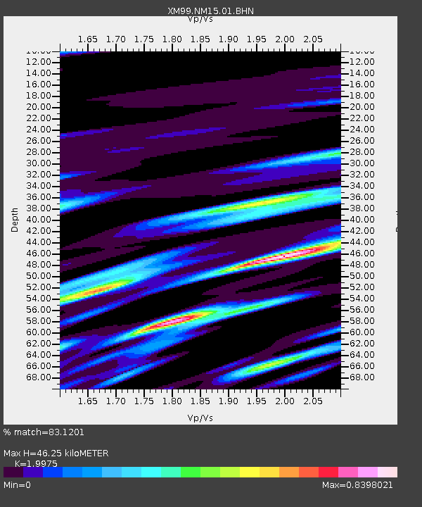
| Estimated Moho Depth: |
46.25 km |
| Estimated Crust Vp/Vs: |
2.00 |
| Assumed Crust Vp: |
6.232 km/s |
| Estimated Crust Vs: |
3.12 km/s |
| Estimated Crust Poisson's Ratio: |
0.33 |
|
| Radial Match: |
83.1201 % |
| Radial Bump: |
400 |
| Transverse Match: |
68.82003 % |
| Transverse Bump: |
400 |
| SOD ConfigId: |
27569 |
| Insert Time: |
2010-02-26 17:25:16.650 +0000 |
| GWidth: |
2.5 |
| Max Bumps: |
400 |
| Tol: |
0.001 |
|
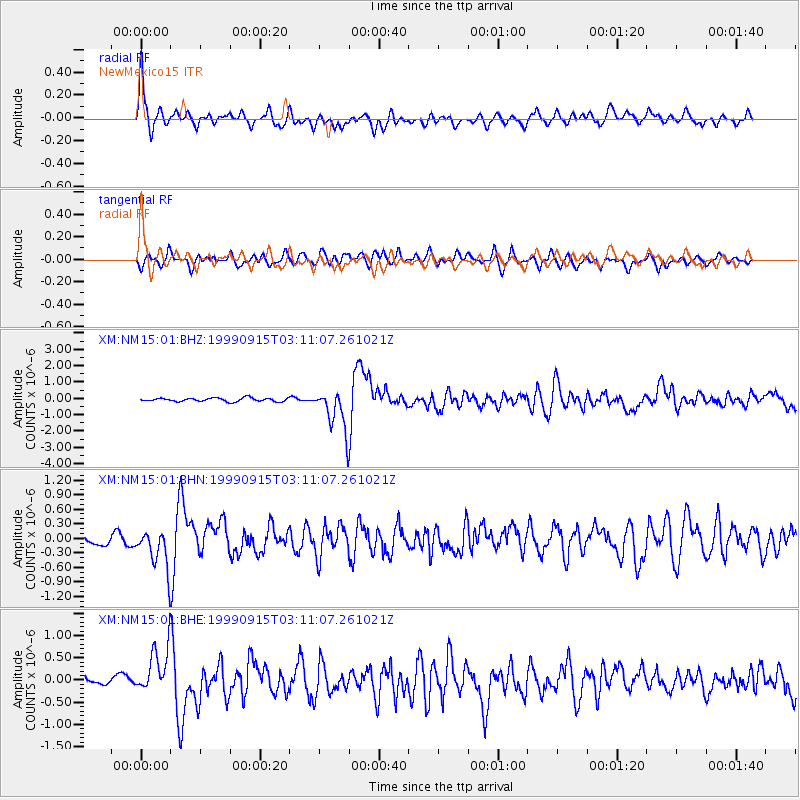
Signal To Noise
| Channel | StoN | STA | LTA |
| XM:NM15:01:BHN:19990915T03:11:07.261021Z | 3.4306228 | 4.2470938E-7 | 1.237995E-7 |
| XM:NM15:01:BHE:19990915T03:11:07.261021Z | 3.17365 | 5.9462326E-7 | 1.8736259E-7 |
| XM:NM15:01:BHZ:19990915T03:11:07.261021Z | 11.9676695 | 1.2790235E-6 | 1.0687324E-7 |
| Arrivals |
| Ps | 7.7 SECOND |
| PpPs | 21 SECOND |
| PsPs/PpSs | 29 SECOND |


