You are here: Home > Network List > XM99 - Rio Grande Seismic Transect Stations List
> Station NM15 NewMexico15 > Earthquake Result Viewer
NM15 NewMexico15 - Earthquake Result Viewer
| Earthquake location: |
Kodiak Island Region, Alaska |
| Earthquake latitude/longitude: |
57.4/-154.5 |
| Earthquake time(UTC): |
1999/12/06 (340) 23:12:33 GMT |
| Earthquake Depth: |
66 km |
| Earthquake Magnitude: |
6.8 MB, 7.0 MW, 7.0 ML |
| Earthquake Catalog/Contributor: |
WHDF/NEIC |
|
| Network: |
XM Rio Grande Seismic Transect |
| Station: |
NM15 NewMexico15 |
| Lat/Lon: |
33.01 N/104.91 W |
| Elevation: |
1342 m |
|
| Distance: |
41.3 deg |
| Az: |
104.436 deg |
| Baz: |
321.411 deg |
| Ray Param: |
0.07364937 |
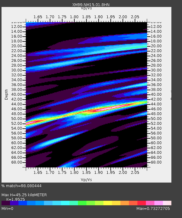
| Estimated Moho Depth: |
45.25 km |
| Estimated Crust Vp/Vs: |
1.95 |
| Assumed Crust Vp: |
6.232 km/s |
| Estimated Crust Vs: |
3.192 km/s |
| Estimated Crust Poisson's Ratio: |
0.32 |
|
| Radial Match: |
98.080444 % |
| Radial Bump: |
274 |
| Transverse Match: |
92.00585 % |
| Transverse Bump: |
400 |
| SOD ConfigId: |
27569 |
| Insert Time: |
2010-02-26 17:25:18.523 +0000 |
| GWidth: |
2.5 |
| Max Bumps: |
400 |
| Tol: |
0.001 |
|

Signal To Noise
| Channel | StoN | STA | LTA |
| XM:NM15:01:BHN:19991206T23:19:42.87401Z | 13.478543 | 1.4469515E-6 | 1.0735222E-7 |
| XM:NM15:01:BHE:19991206T23:19:42.87401Z | 8.827017 | 9.933962E-7 | 1.1254043E-7 |
| XM:NM15:01:BHZ:19991206T23:19:42.87401Z | 12.335119 | 2.8657687E-6 | 2.3232599E-7 |
| Arrivals |
| Ps | 7.3 SECOND |
| PpPs | 20 SECOND |
| PsPs/PpSs | 28 SECOND |


