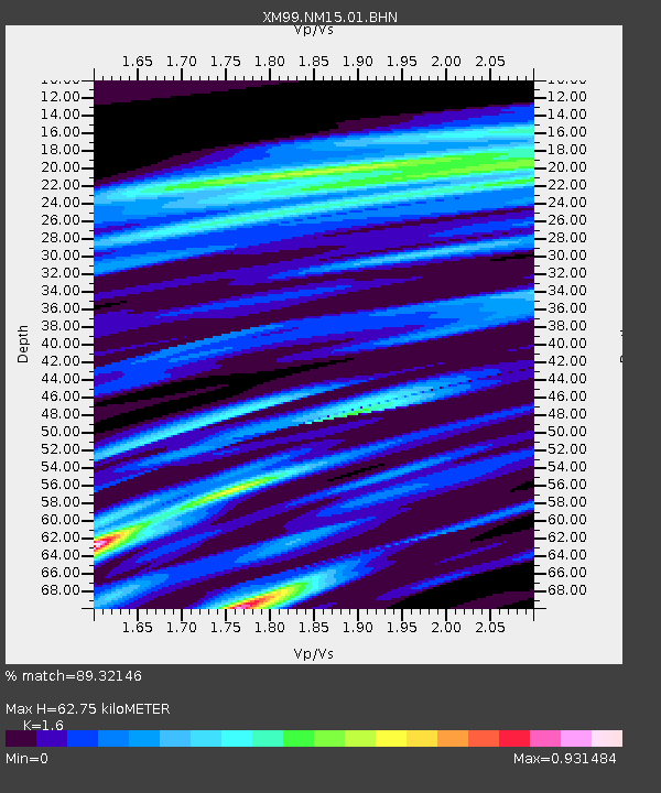
NM15 NewMexico15 - Earthquake Result Viewer
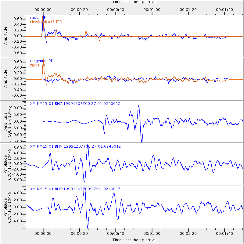
Earthquake location: Kodiak Island Region, Alaska
Earthquake latitude/longitude: 57.4/-154.5
Earthquake time(UTC): 1999/12/07 (341) 00:19:49 GMT
Earthquake Depth: 41 km
Earthquake Magnitude: 6.5 MB, 6.1 MS, 6.4 MW, 6.3 ML
Earthquake Catalog/Contributor: WHDF/NEIC
Network: XM Rio Grande Seismic Transect
Station: NM15 NewMexico15
Lat/Lon: 33.01 N/104.91 W
Elevation: 1342 m
Distance: 41.3 deg
Az: 104.355 deg
Baz: 321.33 deg
Ray Param: 0.073755726
Estimated Moho Depth: 62.75 km
Estimated Crust Vp/Vs: 1.60
Assumed Crust Vp: 6.232 km/s
Estimated Crust Vs: 3.895 km/s
Estimated Crust Poisson's Ratio: 0.18
Radial Match: 89.32146 %
Radial Bump: 400
Transverse Match: 71.55395 %
Transverse Bump: 400
SOD ConfigId: 27569
Insert Time: 2010-02-26 17:25:20.028 +0000
GWidth: 2.5
Max Bumps: 400
Tol: 0.001

Signal To Noise

ChannelStoNSTALTA
XM:NM15:01:BHN:19991207T00:27:01.024001Z8.6645061.7816891E-62.0563077E-7
XM:NM15:01:BHE:19991207T00:27:01.024001Z0.85008717.161065E-78.423919E-7
XM:NM15:01:BHZ:19991207T00:27:01.024001Z4.5978953.0460735E-66.624931E-7
Arrivals
Ps6.5 SECOND
PpPs24 SECOND
PsPs/PpSs31 SECOND