You are here: Home > Network List > XM99 - Rio Grande Seismic Transect Stations List
> Station NM14 NewMexico14 > Earthquake Result Viewer
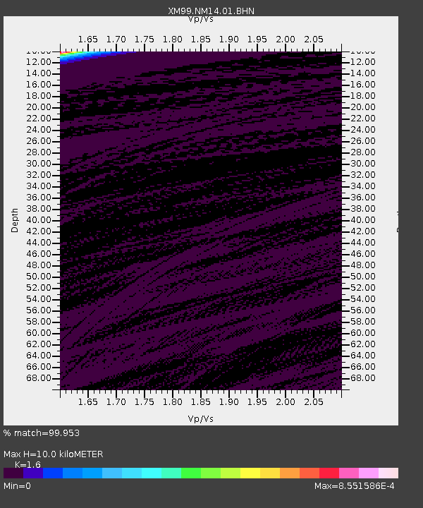
NM14 NewMexico14 - Earthquake Result Viewer
| Earthquake location: |
Santiago Del Estero Prov., Arg. |
| Earthquake latitude/longitude: |
-28.4/-62.9 |
| Earthquake time(UTC): |
2000/04/23 (114) 17:01:17 GMT |
| Earthquake Depth: |
610 km |
| Earthquake Magnitude: |
5.8 MB, 6.2 MW, 6.1 MW |
| Earthquake Catalog/Contributor: |
WHDF/NEIC |
|
| Network: |
XM Rio Grande Seismic Transect |
| Station: |
NM14 NewMexico14 |
| Lat/Lon: |
32.91 N/104.76 W |
| Elevation: |
1219 m |
|
| Distance: |
72.7 deg |
| Az: |
324.033 deg |
| Baz: |
142.035 deg |
| Ray Param: |
0.051400732 |
| Estimated Moho Depth: |
10.0 km |
| Estimated Crust Vp/Vs: |
1.60 |
| Assumed Crust Vp: |
6.232 km/s |
| Estimated Crust Vs: |
3.895 km/s |
| Estimated Crust Poisson's Ratio: |
0.18 |
|
| Radial Match: |
99.953 % |
| Radial Bump: |
6 |
| Transverse Match: |
99.958534 % |
| Transverse Bump: |
4 |
| SOD ConfigId: |
16820 |
| Insert Time: |
2010-02-26 17:25:23.813 +0000 |
| GWidth: |
2.5 |
| Max Bumps: |
400 |
| Tol: |
0.001 |
|

Signal To Noise
| Channel | StoN | STA | LTA |
| XM:NM14:01:BHN:20000423T17:11:14.11502Z | 1.8774395 | 2.4670084E-7 | 1.3140281E-7 |
| XM:NM14:01:BHE:20000423T17:11:14.11502Z | 0.9742293 | 5.2972064E-7 | 5.43733E-7 |
| XM:NM14:01:BHZ:20000423T17:11:14.11502Z | 0.7810568 | 3.5592086E-7 | 4.556914E-7 |
| Arrivals |
| Ps | 1.0 SECOND |
| PpPs | 4.0 SECOND |
| PsPs/PpSs | 5.0 SECOND |


