
Station XM NM14 - NewMexico14
Network: XM99 - Rio Grande Seismic Transect
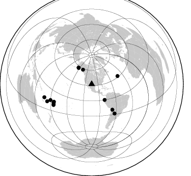
Nearby stations (2 deg radius)
| Station | Name | (Lat, Lon) | Start / End | Elevation |
| NM14 | NewMexico14 | (32.91, -104.76) | 1999-09-10 / 2001-12-31 | 1219 m |
| Crust2 Type: | P2,orogen/38km, Alps and Foreland, 2 km seds. |
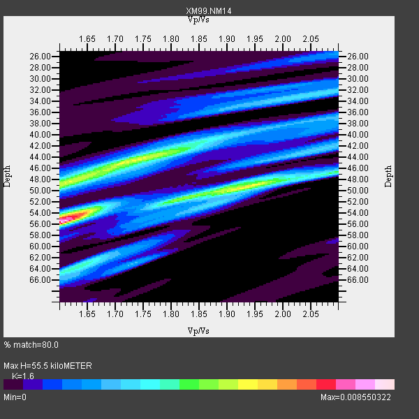
| Thickness Estimate: | 56 km |
| Thickness StdDev: | 5.4 km |
| Vp/Vs Estimate: | 1.60 |
| Vp/Vs StdDev: | 0.13 |
| Vs Estimate: | 3.895 km/s |
| Poisson's Ratio: | 0.18 |
| Peak Value: | 0.01 |
| Assumed Vp: | 6.232 km/s |
| Ps Weight: | 0.33333334 |
| PpPs Weight: | 0.33333334 |
| PsPs Weight: | 0.33333328 |
| Residual Complexity: | 0.791 |
| Nearby stations H: | +- |
| (2.0 deg) Vp/Vs: | +- |
8 with match > 90% ( 44.444443 %) and 15 with match > 80% ( 83.333336 %) out of 18.
Download stack as xyz text file.
Azimuth Distribution of Events:
Prior Results for this Station
| Study | Thickness | Vp/Vs | Vp | Vs | Poissons Ratio | Extra |
| EARS | 56 km | 1.60 | 6.232 km/s | 3.895 km/s | 0.18 | |
| Crust2.0 | 38 km | 1.76 | 6.232 km/s | 3.534 km/s | 0.26 | P2,orogen/38km, Alps and Foreland, 2 km seds. |
| Wilson | 45 km | 1.74 | 6.28 km/s | 3.609 km/s | 0.25 | |
| Global Maxima | 56 km | 1.60 | 6.232 km/s | 3.895 km/s | 0.18 | amp=0.008550322 |
| Local Maxima 1 | 45 km | 1.71 | 6.232 km/s | 3.655 km/s | 0.24 | amp=0.0051166033 |
| Local Maxima 2 | 49 km | 1.60 | 6.232 km/s | 3.889 km/s | 0.18 | amp=0.004323819 |
| Local Maxima 3 | 49 km | 1.93 | 6.232 km/s | 3.22 km/s | 0.32 | amp=0.0037396047 |
| Local Maxima 4 | 64 km | 1.63 | 6.232 km/s | 3.817 km/s | 0.20 | amp=0.0036877203 |
| Predicted Arrivals for vertical incidence (zero ray parameter) | |
| Ps | 5.34 SECOND |
| PpPs | 23.16 SECOND |
| PsPs/PpSs | 28.50 SECOND |
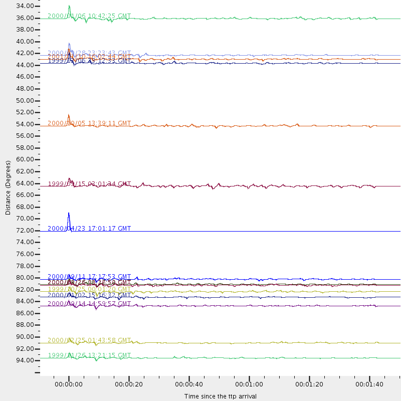
Events Processed for this Station
Download zip of receiver functions as SAC
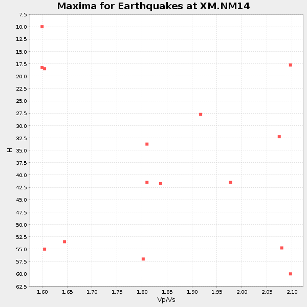
Plot maxima for each earthquake.
Events Used in the Stack
(15 events)| Radial Match | Distance | Baz | FERegion | Time | Lat/Lon | Depth | Magnitude |
| 99.953 | 72.7 deg | 142.035 deg | Santiago Del Estero Prov., Arg. | 2000/04/23 17:01:17 GMT | (-28.4, -62.9) | 610 km | 5.8 MB, 6.2 MW, 6.1 MW |
| 97.90407 | 41.5 deg | 321.456 deg | Kodiak Island Region, Alaska | 1999/12/06 23:12:33 GMT | (57.4, -154.5) | 66 km | 6.8 MB, 7.0 MW, 7.0 ML |
| 97.12684 | 82.7 deg | 244.261 deg | Tonga Islands | 2000/09/26 06:17:52 GMT | (-17.2, -173.9) | 56 km | 6.1 MB, 6.1 MS, 6.4 MW, 6.1 ME |
| 96.62417 | 40.1 deg | 140.476 deg | Near Coast Of Ecuador | 2000/09/28 23:23:43 GMT | (-0.2, -80.6) | 23 km | 5.8 MB, 6.0 MS, 6.6 MW, 6.4 MW |
| 93.744705 | 96.3 deg | 254.639 deg | Vanuatu Islands | 1999/11/26 13:21:15 GMT | (-16.4, 168.2) | 33 km | 6.4 MB, 7.3 MS, 7.5 MW, 7.3 MW |
| 92.8019 | 40.7 deg | 321.233 deg | Kodiak Island Region, Alaska | 2001/01/10 16:02:44 GMT | (57.1, -153.2) | 33 km | 6.2 MB, 6.8 MS, 7.1 MW, 6.8 ML |
| 92.39914 | 86.7 deg | 249.004 deg | Fiji Islands | 2000/09/14 14:59:57 GMT | (-15.7, 179.8) | 33 km | 5.7 MB, 6.2 MS, 6.3 MW, 6.2 MW |
| 90.80368 | 93.5 deg | 249.13 deg | Vanuatu Islands Region | 2000/02/25 01:43:58 GMT | (-19.5, 173.8) | 33 km | 6.1 MB, 7.1 MS, 7.1 MW, 7.0 MW |
| 85.69435 | 53.2 deg | 72.786 deg | Northern Mid-Atlantic Ridge | 2000/10/05 13:39:11 GMT | (31.7, -41.0) | 10 km | 5.4 MB, 6.1 MS, 6.0 MW, 5.9 MW |
| 85.46352 | 81.7 deg | 245.157 deg | Tonga Islands | 2000/09/11 17:17:53 GMT | (-15.9, -173.7) | 115 km | 6.0 MB, 6.3 MW, 6.3 MW |
| 85.24673 | 33.2 deg | 328.904 deg | Southeastern Alaska | 2000/01/06 10:42:25 GMT | (58.0, -136.9) | 1.0 km | 5.5 MB, 5.9 MS, 6.1 MW, 6.1 ML |
| 84.5158 | 84.0 deg | 242.439 deg | Tonga Islands | 1999/10/25 00:01:20 GMT | (-19.4, -173.9) | 33 km | 5.5 MB, 5.6 MS, 5.8 MW, 5.7 MW |
| 84.23207 | 64.4 deg | 140.896 deg | Southern Bolivia | 1999/09/15 03:01:24 GMT | (-20.9, -67.3) | 218 km | 6.0 MB, 6.4 MW, 6.4 MW |
| 82.2829 | 82.8 deg | 244.23 deg | Tonga Islands | 2000/01/26 13:26:50 GMT | (-17.3, -174.0) | 33 km | 5.9 MB, 6.0 MS, 6.4 MW, 6.3 MW |
| 80.84591 | 85.1 deg | 241.595 deg | Tonga Islands | 2000/01/02 15:16:32 GMT | (-20.8, -174.2) | 33 km | 5.5 MB, 5.8 MS, 5.8 MW, 5.8 MW |
Losers
(3 events)| Radial Match | Distance | Baz | FERegion | Time | Lat/Lon | Depth | Magnitude | Reason |
| 99.10001 | 95.7 deg | 257.371 deg | Vanuatu Islands | 1999/09/17 14:54:48 GMT | (-13.8, 167.2) | 197 km | 5.9 MB, 5.5 MS, 6.3 MW, 6.3 MW | |
| 94.61864 | 97.8 deg | 248.948 deg | Southeast Of Loyalty Islands | 2001/02/28 13:05:31 GMT | (-22.0, 170.1) | 10 km | 5.8 MB, 6.1 MS, 6.2 MW | |
| 85.056076 | 96.8 deg | 256.161 deg | Vanuatu Islands | 2000/10/04 16:58:44 GMT | (-15.4, 166.9) | 23 km | 6.1 MB, 6.9 MS, 6.8 MW, 6.5 ME |
