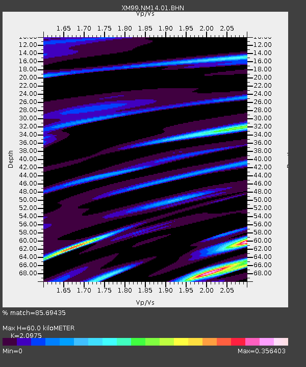
NM14 NewMexico14 - Earthquake Result Viewer
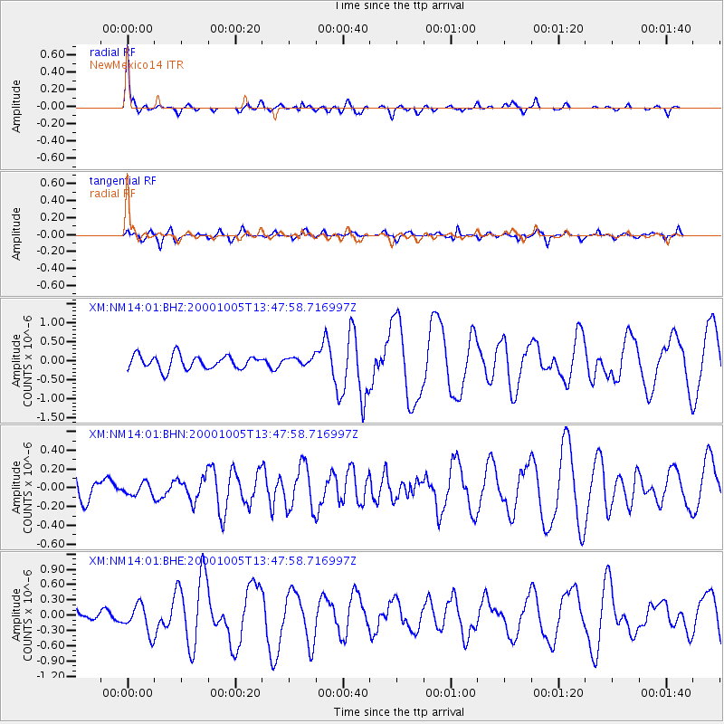
Earthquake location: Northern Mid-Atlantic Ridge
Earthquake latitude/longitude: 31.7/-41.0
Earthquake time(UTC): 2000/10/05 (279) 13:39:11 GMT
Earthquake Depth: 10 km
Earthquake Magnitude: 5.4 MB, 6.1 MS, 6.0 MW, 5.9 MW
Earthquake Catalog/Contributor: WHDF/NEIC
Network: XM Rio Grande Seismic Transect
Station: NM14 NewMexico14
Lat/Lon: 32.91 N/104.76 W
Elevation: 1219 m
Distance: 53.2 deg
Az: 289.437 deg
Baz: 72.786 deg
Ray Param: 0.066280164
Estimated Moho Depth: 60.0 km
Estimated Crust Vp/Vs: 2.10
Assumed Crust Vp: 6.232 km/s
Estimated Crust Vs: 2.971 km/s
Estimated Crust Poisson's Ratio: 0.35
Radial Match: 85.69435 %
Radial Bump: 297
Transverse Match: 57.37319 %
Transverse Bump: 400
SOD ConfigId: 27569
Insert Time: 2010-02-26 17:25:24.638 +0000
GWidth: 2.5
Max Bumps: 400
Tol: 0.001

Signal To Noise

ChannelStoNSTALTA
XM:NM14:01:BHN:20001005T13:47:58.716997Z0.368567386.372863E-81.7290903E-7
XM:NM14:01:BHE:20001005T13:47:58.716997Z1.67654262.8400075E-71.6939667E-7
XM:NM14:01:BHZ:20001005T13:47:58.716997Z0.57082411.0432196E-71.8275675E-7
Arrivals
Ps11 SECOND
PpPs29 SECOND
PsPs/PpSs40 SECOND