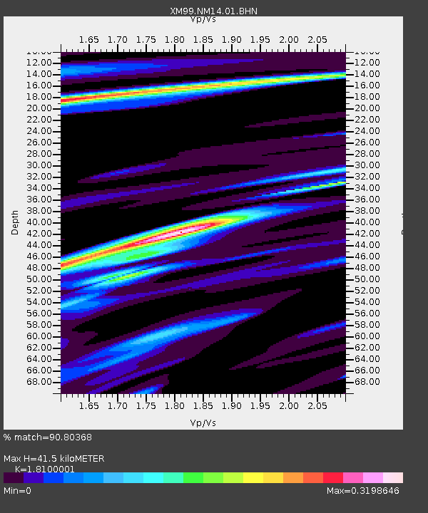
NM14 NewMexico14 - Earthquake Result Viewer

Earthquake location: Vanuatu Islands Region
Earthquake latitude/longitude: -19.5/173.8
Earthquake time(UTC): 2000/02/25 (056) 01:43:58 GMT
Earthquake Depth: 33 km
Earthquake Magnitude: 6.1 MB, 7.1 MS, 7.1 MW, 7.0 MW
Earthquake Catalog/Contributor: WHDF/NEIC
Network: XM Rio Grande Seismic Transect
Station: NM14 NewMexico14
Lat/Lon: 32.91 N/104.76 W
Elevation: 1219 m
Distance: 93.5 deg
Az: 56.447 deg
Baz: 249.13 deg
Ray Param: 0.04123438
Estimated Moho Depth: 41.5 km
Estimated Crust Vp/Vs: 1.81
Assumed Crust Vp: 6.232 km/s
Estimated Crust Vs: 3.443 km/s
Estimated Crust Poisson's Ratio: 0.28
Radial Match: 90.80368 %
Radial Bump: 356
Transverse Match: 79.62246 %
Transverse Bump: 400
SOD ConfigId: 27569
Insert Time: 2010-02-26 17:25:26.231 +0000
GWidth: 2.5
Max Bumps: 400
Tol: 0.001

Signal To Noise

ChannelStoNSTALTA
XM:NM14:01:BHN:20000225T01:56:39.715012Z2.68023064.5938137E-71.7139621E-7
XM:NM14:01:BHE:20000225T01:56:39.715012Z0.593127251.809015E-73.049961E-7
XM:NM14:01:BHZ:20000225T01:56:39.715012Z2.6651143.8306908E-71.437346E-7
Arrivals
Ps5.5 SECOND
PpPs18 SECOND
PsPs/PpSs24 SECOND