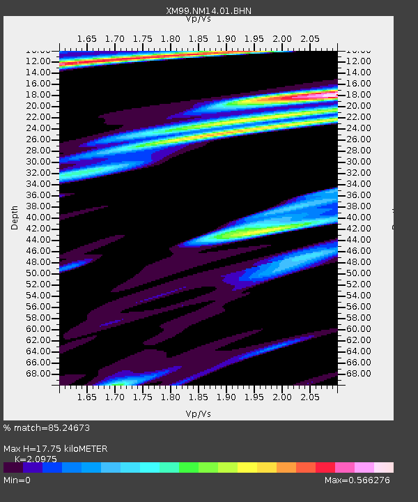
NM14 NewMexico14 - Earthquake Result Viewer

Earthquake location: Southeastern Alaska
Earthquake latitude/longitude: 58.0/-136.9
Earthquake time(UTC): 2000/01/06 (006) 10:42:25 GMT
Earthquake Depth: 1.0 km
Earthquake Magnitude: 5.5 MB, 5.9 MS, 6.1 MW, 6.1 ML
Earthquake Catalog/Contributor: WHDF/NEIC
Network: XM Rio Grande Seismic Transect
Station: NM14 NewMexico14
Lat/Lon: 32.91 N/104.76 W
Elevation: 1219 m
Distance: 33.2 deg
Az: 125.23 deg
Baz: 328.904 deg
Ray Param: 0.07834094
Estimated Moho Depth: 17.75 km
Estimated Crust Vp/Vs: 2.10
Assumed Crust Vp: 6.232 km/s
Estimated Crust Vs: 2.971 km/s
Estimated Crust Poisson's Ratio: 0.35
Radial Match: 85.24673 %
Radial Bump: 315
Transverse Match: 56.74318 %
Transverse Bump: 400
SOD ConfigId: 3744
Insert Time: 2010-02-26 17:25:28.136 +0000
GWidth: 2.5
Max Bumps: 400
Tol: 0.001

Signal To Noise

ChannelStoNSTALTA
XM:NM14:01:BHN:20000106T10:48:32.415009Z1.1491662.4070224E-72.0945821E-7
XM:NM14:01:BHE:20000106T10:48:32.415009Z1.6191474.2365727E-72.616546E-7
XM:NM14:01:BHZ:20000106T10:48:32.415009Z1.21613743.6357505E-72.989589E-7
Arrivals
Ps3.3 SECOND
PpPs8.3 SECOND
PsPs/PpSs12 SECOND