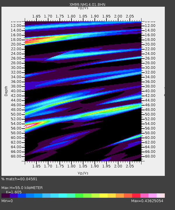
NM14 NewMexico14 - Earthquake Result Viewer
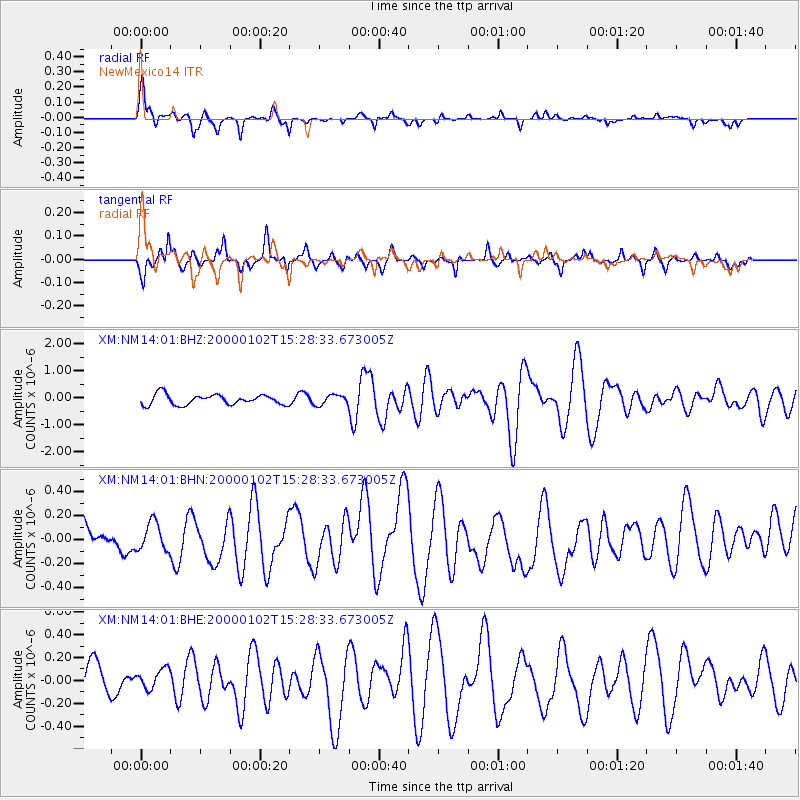
Earthquake location: Tonga Islands
Earthquake latitude/longitude: -20.8/-174.2
Earthquake time(UTC): 2000/01/02 (002) 15:16:32 GMT
Earthquake Depth: 33 km
Earthquake Magnitude: 5.5 MB, 5.8 MS, 5.8 MW, 5.8 MW
Earthquake Catalog/Contributor: WHDF/NEIC
Network: XM Rio Grande Seismic Transect
Station: NM14 NewMexico14
Lat/Lon: 32.91 N/104.76 W
Elevation: 1219 m
Distance: 85.1 deg
Az: 52.252 deg
Baz: 241.595 deg
Ray Param: 0.044961244
Estimated Moho Depth: 55.0 km
Estimated Crust Vp/Vs: 1.61
Assumed Crust Vp: 6.232 km/s
Estimated Crust Vs: 3.883 km/s
Estimated Crust Poisson's Ratio: 0.18
Radial Match: 80.84591 %
Radial Bump: 400
Transverse Match: 77.74452 %
Transverse Bump: 310
SOD ConfigId: 27569
Insert Time: 2010-02-26 17:25:29.052 +0000
GWidth: 2.5
Max Bumps: 400
Tol: 0.001

Signal To Noise

ChannelStoNSTALTA
XM:NM14:01:BHN:20000102T15:28:33.673005Z1.22781971.18805644E-79.6761475E-8
XM:NM14:01:BHE:20000102T15:28:33.673005Z0.83083578.4738225E-81.0199156E-7
XM:NM14:01:BHZ:20000102T15:28:33.673005Z0.96587081.8122229E-71.876258E-7
Arrivals
Ps5.5 SECOND
PpPs22 SECOND
PsPs/PpSs28 SECOND