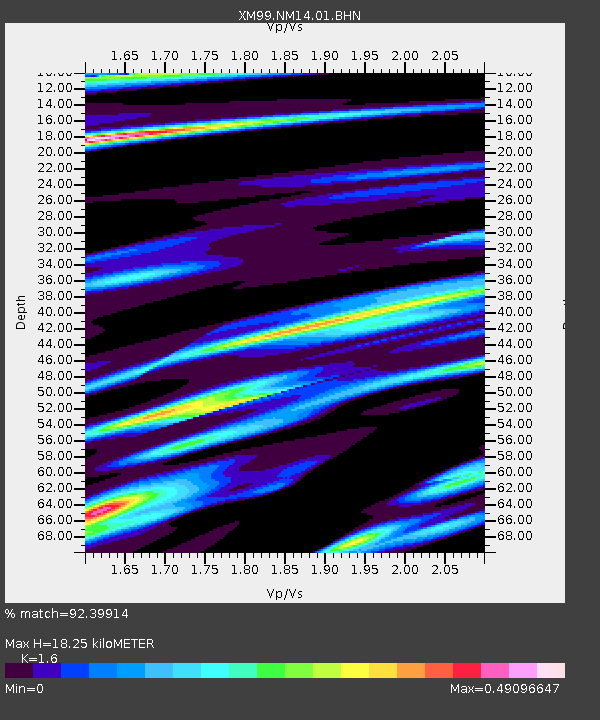
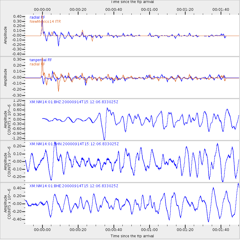
NM14 NewMexico14 - Earthquake Result Viewer

Earthquake location: Fiji Islands
Earthquake latitude/longitude: -15.7/179.8
Earthquake time(UTC): 2000/09/14 (258) 14:59:57 GMT
Earthquake Depth: 33 km
Earthquake Magnitude: 5.7 MB, 6.2 MS, 6.3 MW, 6.2 MW
Earthquake Catalog/Contributor: WHDF/NEIC
Network: XM Rio Grande Seismic Transect
Station: NM14 NewMexico14
Lat/Lon: 32.91 N/104.76 W
Elevation: 1219 m
Distance: 86.7 deg
Az: 54.643 deg
Baz: 249.004 deg
Ray Param: 0.043830663
Estimated Moho Depth: 18.25 km
Estimated Crust Vp/Vs: 1.60
Assumed Crust Vp: 6.232 km/s
Estimated Crust Vs: 3.895 km/s
Estimated Crust Poisson's Ratio: 0.18
Radial Match: 92.39914 %
Radial Bump: 292
Transverse Match: 69.6278 %
Transverse Bump: 400
SOD ConfigId: 16820
Insert Time: 2010-02-26 17:25:31.579 +0000
GWidth: 2.5
Max Bumps: 400
Tol: 0.001

Signal To Noise

ChannelStoNSTALTA
XM:NM14:01:BHN:20000914T15:12:06.833025Z2.07165311.0980296E-75.300258E-8
XM:NM14:01:BHE:20000914T15:12:06.833025Z2.3818611.2997556E-75.456891E-8
XM:NM14:01:BHZ:20000914T15:12:06.833025Z6.80829335.2106765E-77.6534256E-8
Arrivals
Ps1.8 SECOND
PpPs7.4 SECOND
PsPs/PpSs9.2 SECOND