You are here: Home > Network List > XM99 - Rio Grande Seismic Transect Stations List
> Station NM14 NewMexico14 > Earthquake Result Viewer
NM14 NewMexico14 - Earthquake Result Viewer
| Earthquake location: |
Southern Bolivia |
| Earthquake latitude/longitude: |
-20.9/-67.3 |
| Earthquake time(UTC): |
1999/09/15 (258) 03:01:24 GMT |
| Earthquake Depth: |
218 km |
| Earthquake Magnitude: |
6.0 MB, 6.4 MW, 6.4 MW |
| Earthquake Catalog/Contributor: |
WHDF/NEIC |
|
| Network: |
XM Rio Grande Seismic Transect |
| Station: |
NM14 NewMexico14 |
| Lat/Lon: |
32.91 N/104.76 W |
| Elevation: |
1219 m |
|
| Distance: |
64.4 deg |
| Az: |
325.417 deg |
| Baz: |
140.896 deg |
| Ray Param: |
0.058280624 |
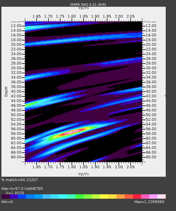
| Estimated Moho Depth: |
57.0 km |
| Estimated Crust Vp/Vs: |
1.80 |
| Assumed Crust Vp: |
6.232 km/s |
| Estimated Crust Vs: |
3.457 km/s |
| Estimated Crust Poisson's Ratio: |
0.28 |
|
| Radial Match: |
84.23207 % |
| Radial Bump: |
400 |
| Transverse Match: |
60.98644 % |
| Transverse Bump: |
346 |
| SOD ConfigId: |
27569 |
| Insert Time: |
2010-02-26 17:25:34.777 +0000 |
| GWidth: |
2.5 |
| Max Bumps: |
400 |
| Tol: |
0.001 |
|
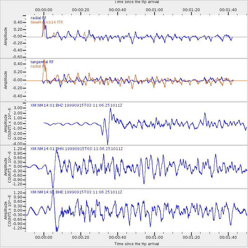
Signal To Noise
| Channel | StoN | STA | LTA |
| XM:NM14:01:BHN:19990915T03:11:06.251011Z | 3.6976204 | 4.4386366E-7 | 1.2004035E-7 |
| XM:NM14:01:BHE:19990915T03:11:06.251011Z | 3.7478201 | 4.422858E-7 | 1.18011485E-7 |
| XM:NM14:01:BHZ:19990915T03:11:06.251011Z | 9.654101 | 1.4662079E-6 | 1.5187409E-7 |
| Arrivals |
| Ps | 7.6 SECOND |
| PpPs | 25 SECOND |
| PsPs/PpSs | 32 SECOND |


