You are here: Home > Network List > XM99 - Rio Grande Seismic Transect Stations List
> Station NM14 NewMexico14 > Earthquake Result Viewer
NM14 NewMexico14 - Earthquake Result Viewer
| Earthquake location: |
Kodiak Island Region, Alaska |
| Earthquake latitude/longitude: |
57.4/-154.5 |
| Earthquake time(UTC): |
1999/12/06 (340) 23:12:33 GMT |
| Earthquake Depth: |
66 km |
| Earthquake Magnitude: |
6.8 MB, 7.0 MW, 7.0 ML |
| Earthquake Catalog/Contributor: |
WHDF/NEIC |
|
| Network: |
XM Rio Grande Seismic Transect |
| Station: |
NM14 NewMexico14 |
| Lat/Lon: |
32.91 N/104.76 W |
| Elevation: |
1219 m |
|
| Distance: |
41.5 deg |
| Az: |
104.388 deg |
| Baz: |
321.456 deg |
| Ray Param: |
0.073545665 |
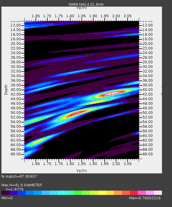
| Estimated Moho Depth: |
41.5 km |
| Estimated Crust Vp/Vs: |
1.98 |
| Assumed Crust Vp: |
6.232 km/s |
| Estimated Crust Vs: |
3.151 km/s |
| Estimated Crust Poisson's Ratio: |
0.33 |
|
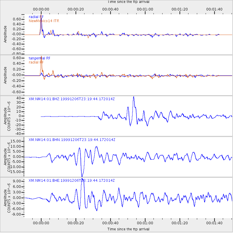
| Radial Match: |
97.90407 % |
| Radial Bump: |
349 |
| Transverse Match: |
88.47403 % |
| Transverse Bump: |
400 |
| SOD ConfigId: |
27569 |
| Insert Time: |
2010-02-26 17:25:37.298 +0000 |
| GWidth: |
2.5 |
| Max Bumps: |
400 |
| Tol: |
0.001 |
|
Signal To Noise
| Channel | StoN | STA | LTA |
| XM:NM14:01:BHN:19991206T23:19:44.172014Z | 9.910488 | 1.3863421E-6 | 1.3988637E-7 |
| XM:NM14:01:BHE:19991206T23:19:44.172014Z | 3.8781474 | 7.693926E-7 | 1.983918E-7 |
| XM:NM14:01:BHZ:19991206T23:19:44.172014Z | 14.823497 | 2.9952969E-6 | 2.0206413E-7 |
| Arrivals |
| Ps | 6.9 SECOND |
| PpPs | 19 SECOND |
| PsPs/PpSs | 26 SECOND |


