You are here: Home > Network List > XJ00 - Eastern Snake River Plain Experiment Stations List
> Station NST North Senter > Earthquake Result Viewer
NST North Senter - Earthquake Result Viewer
| Earthquake location: |
Near Coast Of Peru |
| Earthquake latitude/longitude: |
-16.1/-74.0 |
| Earthquake time(UTC): |
2001/07/05 (186) 13:53:48 GMT |
| Earthquake Depth: |
62 km |
| Earthquake Magnitude: |
6.2 MB, 6.6 MW, 6.5 ME |
| Earthquake Catalog/Contributor: |
WHDF/NEIC |
|
| Network: |
XJ Eastern Snake River Plain Experiment |
| Station: |
NST North Senter |
| Lat/Lon: |
42.91 N/113.98 W |
| Elevation: |
1311 m |
|
| Distance: |
69.2 deg |
| Az: |
329.672 deg |
| Baz: |
138.648 deg |
| Ray Param: |
0.05563712 |
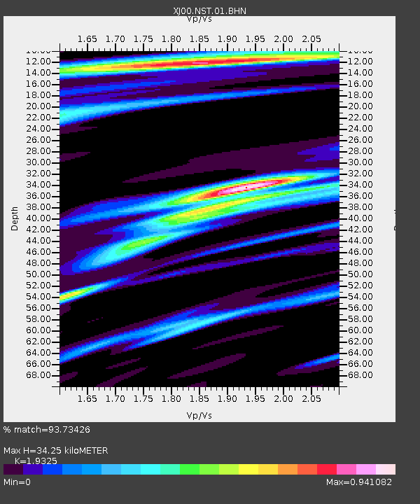
| Estimated Moho Depth: |
34.25 km |
| Estimated Crust Vp/Vs: |
1.93 |
| Assumed Crust Vp: |
6.279 km/s |
| Estimated Crust Vs: |
3.249 km/s |
| Estimated Crust Poisson's Ratio: |
0.32 |
|
| Radial Match: |
93.73426 % |
| Radial Bump: |
400 |
| Transverse Match: |
73.00326 % |
| Transverse Bump: |
400 |
| SOD ConfigId: |
4714 |
| Insert Time: |
2010-03-09 20:03:26.954 +0000 |
| GWidth: |
2.5 |
| Max Bumps: |
400 |
| Tol: |
0.001 |
|

Signal To Noise
| Channel | StoN | STA | LTA |
| XJ:NST:01:BHN:20010705T14:04:17.956008Z | 0.64635384 | 1.0861107E-7 | 1.6803655E-7 |
| XJ:NST:01:BHE:20010705T14:04:17.956008Z | 0.69864935 | 9.867425E-8 | 1.4123573E-7 |
| XJ:NST:01:BHZ:20010705T14:04:17.956008Z | 2.8211312 | 2.8566996E-7 | 1.0126078E-7 |
| Arrivals |
| Ps | 5.3 SECOND |
| PpPs | 15 SECOND |
| PsPs/PpSs | 21 SECOND |


