
Station XJ NST - North Senter
Network: XJ00 - Eastern Snake River Plain Experiment
Nearby stations (2 deg radius)
| Station | Name | (Lat, Lon) | Start / End | Elevation |
| NST | North Senter | (42.91, -113.98) | 2000-07-17 / 2001-12-31 | 1311 m |
| Crust2 Type: | M7,medium thick extended crust, 0.5 km seds. |
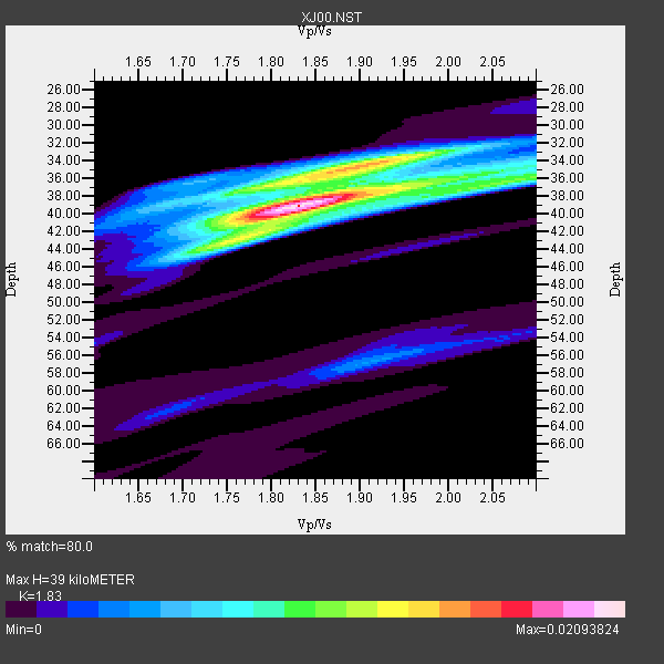
| Thickness Estimate: | 39 km |
| Thickness StdDev: | 1.7 km |
| Vp/Vs Estimate: | 1.83 |
| Vp/Vs StdDev: | 0.07 |
| Vs Estimate: | 3.431 km/s |
| Poisson's Ratio: | 0.29 |
| Peak Value: | 0.02 |
| Assumed Vp: | 6.279 km/s |
| Ps Weight: | 0.33333334 |
| PpPs Weight: | 0.33333334 |
| PsPs Weight: | 0.33333328 |
| Residual Complexity: | 0.576 |
| Nearby stations H: | +- |
| (2.0 deg) Vp/Vs: | +- |
8 with match > 90% ( 61.53846 %) and 13 with match > 80% ( 100.0 %) out of 13.
Download stack as xyz text file.
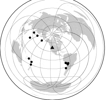
Azimuth Distribution of Events:
Prior Results for this Station
| Study | Thickness | Vp/Vs | Vp | Vs | Poissons Ratio | Extra |
| EARS | 39 km | 1.83 | 6.279 km/s | 3.431 km/s | 0.29 | |
| Crust2.0 | 35 km | 1.78 | 6.279 km/s | 3.533 km/s | 0.27 | M7,medium thick extended crust, 0.5 km seds. |
| Global Maxima | 39 km | 1.83 | 6.279 km/s | 3.431 km/s | 0.29 | amp=0.02093824 |
| Local Maxima 1 | 35 km | 1.86 | 6.279 km/s | 3.371 km/s | 0.30 | amp=0.012013367 |
| Local Maxima 2 | 35 km | 2.05 | 6.279 km/s | 3.066 km/s | 0.34 | amp=0.008192696 |
| Local Maxima 3 | 42 km | 1.78 | 6.279 km/s | 3.532 km/s | 0.27 | amp=0.0073614116 |
| Local Maxima 4 | 38 km | 1.75 | 6.279 km/s | 3.593 km/s | 0.26 | amp=0.0055302326 |
| Predicted Arrivals for vertical incidence (zero ray parameter) | |
| Ps | 5.16 SECOND |
| PpPs | 17.58 SECOND |
| PsPs/PpSs | 22.73 SECOND |
Events Processed for this Station
Download zip of receiver functions as SAC
Plot maxima for each earthquake.
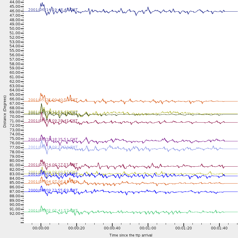
Events Used in the Stack
(13 events)| Radial Match | Distance | Baz | FERegion | Time | Lat/Lon | Depth | Magnitude |
| 97.795135 | 69.6 deg | 138.438 deg | Near Coast Of Peru | 2001/06/23 20:33:14 GMT | (-16.3, -73.6) | 33 km | 6.7 MB, 8.2 MS, 8.4 MW, 7.8 ME |
| 95.647 | 71.4 deg | 137.765 deg | Near Coast Of Peru | 2001/07/07 09:38:43 GMT | (-17.5, -72.1) | 33 km | 6.6 MB, 7.3 MS, 7.6 MW, 7.5 ME |
| 94.17908 | 84.0 deg | 146.295 deg | Off Coast Of Central Chile | 2001/04/09 09:00:57 GMT | (-32.7, -73.1) | 11 km | 6.1 MB, 6.3 MS, 6.7 MW, 6.3 ME |
| 93.73426 | 69.2 deg | 138.648 deg | Near Coast Of Peru | 2001/07/05 13:53:48 GMT | (-16.1, -74.0) | 62 km | 6.2 MB, 6.6 MW, 6.5 ME |
| 92.91306 | 82.2 deg | 309.806 deg | Western Honshu, Japan | 2001/03/24 06:27:53 GMT | (34.1, 132.5) | 50 km | 6.4 MB, 6.5 MS, 6.8 MW, 6.4 ME |
| 91.36111 | 93.5 deg | 232.0 deg | Kermadec Islands, New Zealand | 2001/06/03 02:41:57 GMT | (-29.7, -178.6) | 178 km | 6.8 MB, 7.2 MW, 7.1 MW |
| 90.96931 | 86.4 deg | 235.906 deg | Fiji Islands Region | 2001/07/04 07:06:31 GMT | (-21.7, -176.7) | 185 km | 5.9 MB, 5.8 MS, 6.5 MW, 6.5 MW |
| 90.845024 | 66.3 deg | 308.959 deg | Kuril Islands | 2001/05/25 00:40:50 GMT | (44.3, 148.4) | 33 km | 6.1 MB, 6.7 MS, 6.7 MW, 6.6 MW |
| 84.7321 | 84.6 deg | 294.433 deg | Mariana Islands Region | 2001/07/03 13:10:42 GMT | (21.6, 143.0) | 290 km | 6.0 MB, 6.5 MW, 6.5 MW |
| 83.957275 | 76.1 deg | 134.023 deg | Southern Bolivia | 2001/06/29 18:35:51 GMT | (-19.5, -66.3) | 274 km | 5.7 MB, 6.1 MW, 6.1 MW |
| 83.81136 | 77.9 deg | 137.13 deg | Chile-Bolivia Border Region | 2001/06/19 09:32:24 GMT | (-22.7, -67.9) | 147 km | 5.5 MB, 5.2 MS, 6.1 MW, 5.9 MW |
| 83.69688 | 44.3 deg | 304.574 deg | Andreanof Islands, Aleutian Is. | 2001/06/14 19:48:47 GMT | (51.2, -179.8) | 18 km | 6.0 MB, 6.3 MS, 6.5 MW, 6.1 ML |
| 81.08212 | 88.5 deg | 245.462 deg | Fiji Islands Region | 2000/08/09 22:55:59 GMT | (-16.8, 174.3) | 33 km | 5.7 MB, 6.3 MS, 6.4 MW, 6.4 MW |
Losers
(0 events)| Radial Match | Distance | Baz | FERegion | Time | Lat/Lon | Depth | Magnitude | Reason |
