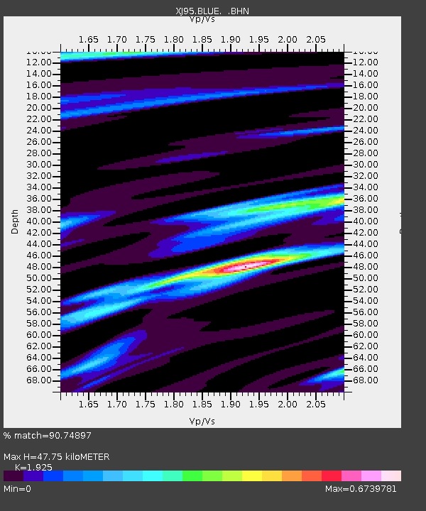
BLUE Blue Mountain Lake, NY - Earthquake Result Viewer

Earthquake location: Unimak Island Region, Alaska
Earthquake latitude/longitude: 53.6/-163.5
Earthquake time(UTC): 1995/07/08 (189) 17:15:28 GMT
Earthquake Depth: 33 km
Earthquake Magnitude: 5.8 MB, 5.7 MS, 5.5 UNKNOWN, 6.0 MW
Earthquake Catalog/Contributor: WHDF/NEIC
Network: XJ Adirondack Broadband Array
Station: BLUE Blue Mountain Lake, NY
Lat/Lon: 43.89 N/74.45 W
Elevation: 601 m
Distance: 55.8 deg
Az: 60.913 deg
Baz: 313.974 deg
Ray Param: 0.06449164
Estimated Moho Depth: 47.75 km
Estimated Crust Vp/Vs: 1.92
Assumed Crust Vp: 6.419 km/s
Estimated Crust Vs: 3.335 km/s
Estimated Crust Poisson's Ratio: 0.32
Radial Match: 90.74897 %
Radial Bump: 328
Transverse Match: 47.673115 %
Transverse Bump: 400
SOD ConfigId: 6273
Insert Time: 2010-03-09 20:03:40.968 +0000
GWidth: 2.5
Max Bumps: 400
Tol: 0.001

Signal To Noise

ChannelStoNSTALTA
XJ:BLUE: :BHN:19950708T17:24:31.352014Z2.3280882.1334303E-79.1638725E-8
XJ:BLUE: :BHE:19950708T17:24:31.352014Z1.71701531.2715289E-77.4054604E-8
XJ:BLUE: :BHZ:19950708T17:24:31.352014Z3.0388353.6493157E-71.200893E-7
Arrivals
Ps7.2 SECOND
PpPs21 SECOND
PsPs/PpSs28 SECOND