
Station XJ BLUE - Blue Mountain Lake, NY
Network: XJ95 - Adirondack Broadband Array
Nearby stations (2 deg radius)

| Station | Name | (Lat, Lon) | Start / End | Elevation |
| BLUE | Blue Mountain Lake, NY | (43.89, -74.45) | 1995-05-24 / 1996-12-31 | 601 m |
| Crust2 Type: | Q2,orogen/39km no ice, Appalachians, North Andes, 0.5 km seds. |
| Thickness Estimate: | 36 km |
| Thickness StdDev: | 4.0 km |
| Vp/Vs Estimate: | 1.96 |
| Vp/Vs StdDev: | 0.10 |
| Vs Estimate: | 3.271 km/s |
| Poisson's Ratio: | 0.32 |
| Peak Value: | 0.02 |
| Assumed Vp: | 6.419 km/s |
| Ps Weight: | 0.33333334 |
| PpPs Weight: | 0.33333334 |
| PsPs Weight: | 0.33333328 |
| Residual Complexity: | 0.679 |
| Nearby stations H: | +- |
| (2.0 deg) Vp/Vs: | +- |
6 with match > 90% ( 37.5 %) and 11 with match > 80% ( 68.75 %) out of 16.
Download stack as xyz text file.
Azimuth Distribution of Events:

Prior Results for this Station
| Study | Thickness | Vp/Vs | Vp | Vs | Poissons Ratio | Extra |
| EARS | 36 km | 1.96 | 6.419 km/s | 3.271 km/s | 0.32 | |
| Crust2.0 | 39 km | 1.75 | 6.419 km/s | 3.659 km/s | 0.26 | Q2,orogen/39km no ice, Appalachians, North Andes, 0.5 km seds. |
| Global Maxima | 36 km | 1.96 | 6.419 km/s | 3.271 km/s | 0.32 | amp=0.01570091 |
| Local Maxima 1 | 42 km | 1.87 | 6.419 km/s | 3.437 km/s | 0.30 | amp=0.009354906 |
| Local Maxima 2 | 36 km | 2.09 | 6.419 km/s | 3.068 km/s | 0.35 | amp=0.008381226 |
| Local Maxima 3 | 46 km | 1.79 | 6.419 km/s | 3.596 km/s | 0.27 | amp=0.0071262694 |
| Local Maxima 4 | 43 km | 1.78 | 6.419 km/s | 3.611 km/s | 0.27 | amp=0.006293279 |
| Predicted Arrivals for vertical incidence (zero ray parameter) | |
| Ps | 5.36 SECOND |
| PpPs | 16.50 SECOND |
| PsPs/PpSs | 21.86 SECOND |
Events Processed for this Station
Download zip of receiver functions as SAC
Plot maxima for each earthquake.
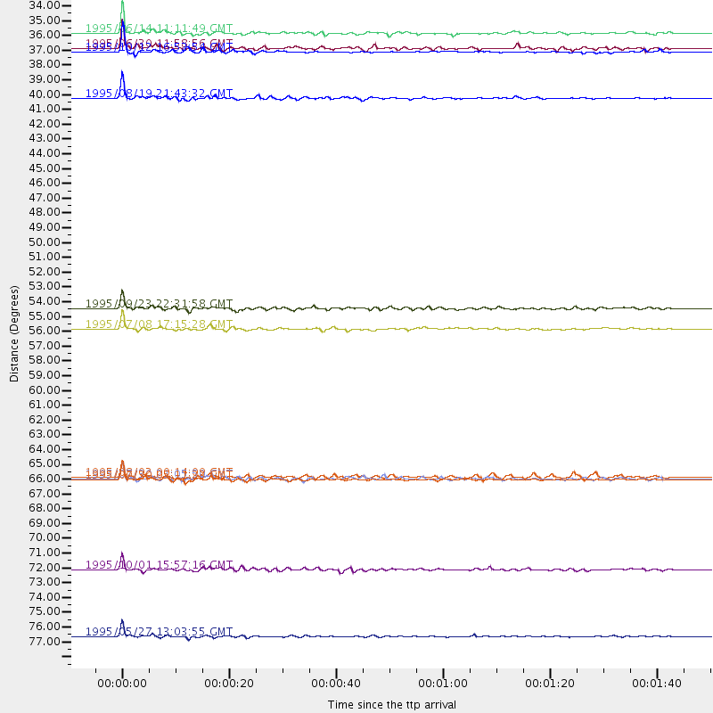
Events Used in the Stack
(11 events)| Radial Match | Distance | Baz | FERegion | Time | Lat/Lon | Depth | Magnitude |
| 98.374756 | 78.7 deg | 337.854 deg | Sakhalin, Russia | 1995/05/27 13:03:55 GMT | (52.6, 142.8) | 33 km | 6.6 MB, 7.6 MS, 7.0 UNKNOWN, 7.0 MW |
| 97.48534 | 67.0 deg | 175.866 deg | Near Coast Of Northern Chile | 1995/07/30 05:11:23 GMT | (-23.4, -70.3) | 47 km | 6.6 MB, 7.3 MS, 7.2 UNKNOWN, 8.1 MW |
| 95.79093 | 38.7 deg | 181.971 deg | Colombia | 1995/08/19 21:43:32 GMT | (5.1, -75.7) | 125 km | 6.1 MB, 6.6 UNKNOWN, 6.5 MW |
| 95.03353 | 33.8 deg | 204.984 deg | Off Coast Of Central America | 1995/06/14 11:11:49 GMT | (12.2, -88.3) | 39 km | 5.6 MB, 6.0 MS, 6.6 UNKNOWN |
| 91.233505 | 34.9 deg | 248.438 deg | Baja California, Mexico | 1995/06/30 11:58:56 GMT | (24.6, -110.3) | 10 km | 5.8 MB, 6.3 MS, 6.2 UNKNOWN |
| 90.74897 | 55.8 deg | 313.974 deg | Unimak Island Region, Alaska | 1995/07/08 17:15:28 GMT | (53.6, -163.5) | 33 km | 5.8 MB, 5.7 MS, 5.5 UNKNOWN, 6.0 MW |
| 86.106606 | 35.2 deg | 234.179 deg | Near Coast Of Jalisco, Mexico | 1995/10/12 16:52:54 GMT | (18.8, -104.0) | 25 km | 5.5 MB, 5.5 MS, 5.2 UNKNOWN, 6.0 MW |
| 86.07229 | 54.3 deg | 185.14 deg | Near Coast Of Peru | 1995/09/23 22:31:58 GMT | (-10.5, -78.7) | 73 km | 5.9 MB, 6.5 UNKNOWN, 6.4 MW |
| 85.51598 | 73.7 deg | 52.683 deg | Turkey | 1995/10/01 15:57:16 GMT | (38.1, 30.2) | 33 km | 5.7 MB, 6.1 MS, 6.3 UNKNOWN, 6.0 MW |
| 80.648506 | 67.0 deg | 176.14 deg | Near Coast Of Northern Chile | 1995/07/30 21:05:50 GMT | (-23.3, -70.6) | 33 km | 5.6 MB, 5.6 MS, 5.4 UNKNOWN, 6.1 MW |
| 80.61795 | 66.8 deg | 176.119 deg | Near Coast Of Northern Chile | 1995/08/02 00:14:09 GMT | (-23.2, -70.6) | 33 km | 5.4 MB, 5.5 MS, 5.3 UNKNOWN |
Losers
(5 events)| Radial Match | Distance | Baz | FERegion | Time | Lat/Lon | Depth | Magnitude | Reason |
| 90.64159 | 67.0 deg | 175.874 deg | Near Coast Of Northern Chile | 1995/07/30 05:47:02 GMT | (-23.3, -70.3) | 33 km | 5.8 MB | |
| 76.1876 | 84.1 deg | 205.618 deg | Southern East Pacific Rise | 1995/10/12 23:41:45 GMT | (-35.4, -106.2) | 10 km | 5.5 MB, 5.3 MS, 5.9 UNKNOWN | |
| 72.453575 | 33.4 deg | 216.489 deg | Off Coast Of Chiapas, Mexico | 1995/09/06 22:48:52 GMT | (15.0, -94.3) | 33 km | 5.8 MB, 5.5 MS | |
| 57.567886 | 80.1 deg | 354.93 deg | East Of Lake Baykal, Russia | 1995/11/13 08:43:14 GMT | (56.1, 114.5) | 24 km | 5.9 MB, 5.6 MS, 5.8 UNKNOWN | |
| 56.025116 | 78.2 deg | 329.389 deg | Kuril Islands | 1995/06/29 07:45:09 GMT | (48.8, 154.5) | 62 km | 5.9 MB, 6.0 UNKNOWN, 6.0 MW |
