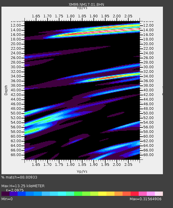
NM17 NewMexico17 - Earthquake Result Viewer

Earthquake location: Tonga Islands
Earthquake latitude/longitude: -20.8/-174.2
Earthquake time(UTC): 2000/01/02 (002) 15:16:32 GMT
Earthquake Depth: 33 km
Earthquake Magnitude: 5.5 MB, 5.8 MS, 5.8 MW, 5.8 MW
Earthquake Catalog/Contributor: WHDF/NEIC
Network: XM Rio Grande Seismic Transect
Station: NM17 NewMexico17
Lat/Lon: 33.26 N/105.17 W
Elevation: 1705 m
Distance: 85.0 deg
Az: 51.777 deg
Baz: 241.329 deg
Ray Param: 0.045060907
Estimated Moho Depth: 13.25 km
Estimated Crust Vp/Vs: 2.10
Assumed Crust Vp: 6.232 km/s
Estimated Crust Vs: 2.971 km/s
Estimated Crust Poisson's Ratio: 0.35
Radial Match: 88.80933 %
Radial Bump: 311
Transverse Match: 65.430565 %
Transverse Bump: 400
SOD ConfigId: 16820
Insert Time: 2010-02-26 17:25:41.744 +0000
GWidth: 2.5
Max Bumps: 400
Tol: 0.001

Signal To Noise

ChannelStoNSTALTA
XM:NM17:01:BHN:20000102T15:28:32.951021Z0.651871447.715144E-81.1835377E-7
XM:NM17:01:BHE:20000102T15:28:32.951021Z0.882762259.1431545E-81.0357437E-7
XM:NM17:01:BHZ:20000102T15:28:32.951021Z1.02692661.3874397E-71.35106E-7
Arrivals
Ps2.4 SECOND
PpPs6.5 SECOND
PsPs/PpSs8.8 SECOND