
Station XM NM17 - NewMexico17
Network: XM99 - Rio Grande Seismic Transect
Nearby stations (2 deg radius)

| Station | Name | (Lat, Lon) | Start / End | Elevation |
| NM17 | NewMexico17 | (33.26, -105.17) | 1999-09-18 / 2001-12-31 | 1705 m |
| Crust2 Type: | P2,orogen/38km, Alps and Foreland, 2 km seds. |
| Thickness Estimate: | 27 km |
| Thickness StdDev: | 11 km |
| Vp/Vs Estimate: | 1.61 |
| Vp/Vs StdDev: | 0.10 |
| Vs Estimate: | 3.871 km/s |
| Poisson's Ratio: | 0.19 |
| Peak Value: | 0.01 |
| Assumed Vp: | 6.232 km/s |
| Ps Weight: | 0.33333334 |
| PpPs Weight: | 0.33333334 |
| PsPs Weight: | 0.33333328 |
| Residual Complexity: | 0.827 |
| Nearby stations H: | +- |
| (2.0 deg) Vp/Vs: | +- |
4 with match > 90% ( 25.0 %) and 14 with match > 80% ( 87.5 %) out of 16.
Download stack as xyz text file.
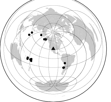
Azimuth Distribution of Events:
Prior Results for this Station
| Study | Thickness | Vp/Vs | Vp | Vs | Poissons Ratio | Extra |
| EARS | 27 km | 1.61 | 6.232 km/s | 3.871 km/s | 0.19 | |
| Crust2.0 | 38 km | 1.76 | 6.232 km/s | 3.534 km/s | 0.26 | P2,orogen/38km, Alps and Foreland, 2 km seds. |
| Wilson | 48 km | 1.75 | 6.28 km/s | 3.589 km/s | 0.26 | |
| Global Maxima | 27 km | 1.61 | 6.232 km/s | 3.871 km/s | 0.19 | amp=0.010435791 |
| Local Maxima 1 | 45 km | 2.10 | 6.232 km/s | 2.971 km/s | 0.35 | amp=0.0055164923 |
| Local Maxima 2 | 46 km | 1.76 | 6.232 km/s | 3.541 km/s | 0.26 | amp=0.0048532523 |
| Local Maxima 3 | 26 km | 1.60 | 6.232 km/s | 3.895 km/s | 0.18 | amp=0.0038489944 |
| Local Maxima 4 | 53 km | 1.66 | 6.232 km/s | 3.754 km/s | 0.22 | amp=0.0038039987 |
| Predicted Arrivals for vertical incidence (zero ray parameter) | |
| Ps | 2.67 SECOND |
| PpPs | 11.41 SECOND |
| PsPs/PpSs | 14.08 SECOND |
Events Processed for this Station
Download zip of receiver functions as SAC
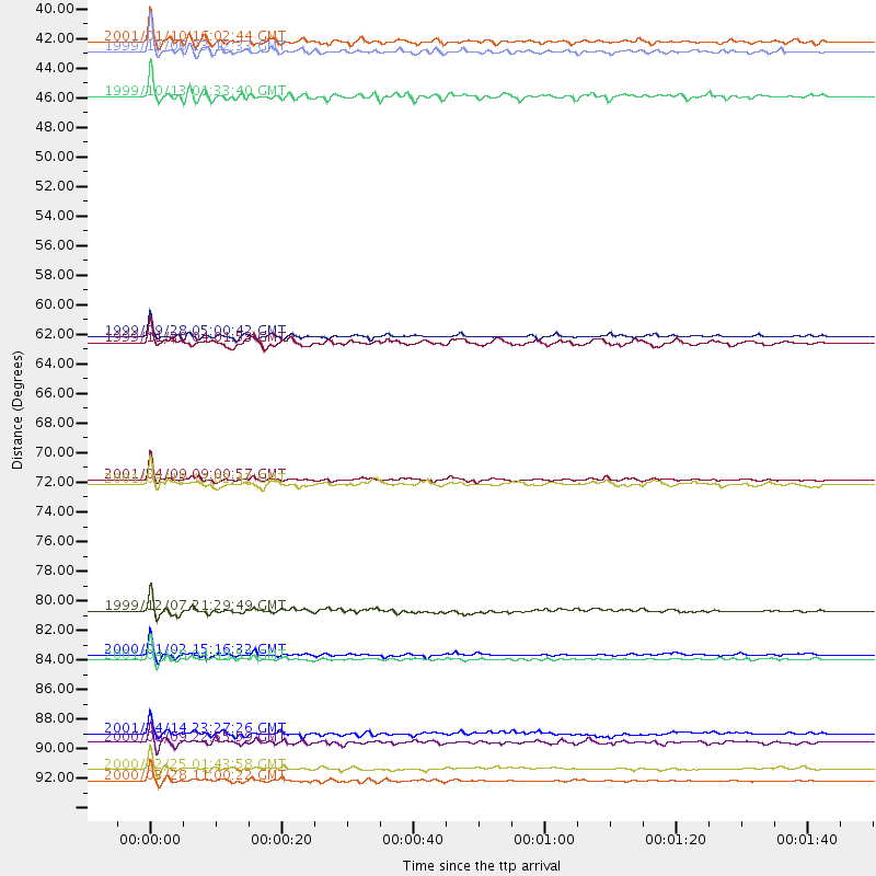
Plot maxima for each earthquake.
Events Used in the Stack
(14 events)| Radial Match | Distance | Baz | FERegion | Time | Lat/Lon | Depth | Magnitude |
| 97.54559 | 41.0 deg | 321.292 deg | Kodiak Island Region, Alaska | 1999/12/06 23:12:33 GMT | (57.4, -154.5) | 66 km | 6.8 MB, 7.0 MW, 7.0 ML |
| 96.98199 | 94.2 deg | 299.991 deg | Volcano Islands, Japan Region | 2000/03/28 11:00:22 GMT | (22.3, 143.7) | 126 km | 6.8 MB, 7.6 MS, 7.6 MW, 7.6 MW |
| 95.08099 | 72.2 deg | 151.947 deg | Off Coast Of Central Chile | 2001/04/09 09:00:57 GMT | (-32.7, -73.1) | 11 km | 6.1 MB, 6.3 MS, 6.7 MW, 6.3 ME |
| 92.78393 | 85.3 deg | 245.031 deg | Fiji Islands Region | 2001/04/28 04:49:53 GMT | (-18.1, -176.9) | 352 km | 6.2 MB, 6.8 MW, 6.8 MW |
| 89.0253 | 44.2 deg | 316.328 deg | Alaska Peninsula | 1999/10/13 01:33:40 GMT | (54.7, -161.2) | 30 km | 6.0 MB, 6.2 MS, 6.5 MW, 6.0 ML |
| 88.80933 | 85.0 deg | 241.329 deg | Tonga Islands | 2000/01/02 15:16:32 GMT | (-20.8, -174.2) | 33 km | 5.5 MB, 5.8 MS, 5.8 MW, 5.8 MW |
| 88.31548 | 72.5 deg | 150.514 deg | Near Coast Of Central Chile | 2001/03/15 13:02:42 GMT | (-32.3, -71.5) | 37 km | 6.1 MB, 5.6 MS, 6.0 MW, 5.4 MD |
| 85.291885 | 90.7 deg | 307.109 deg | Southeast Of Honshu, Japan | 2001/04/14 23:27:26 GMT | (30.1, 141.8) | 10 km | 6.0 MB, 5.8 MS, 6.0 MW, 6.0 ME |
| 84.41484 | 93.3 deg | 248.932 deg | Vanuatu Islands Region | 2000/02/25 01:43:58 GMT | (-19.5, 173.8) | 33 km | 6.1 MB, 7.1 MS, 7.1 MW, 7.0 MW |
| 84.13655 | 81.8 deg | 245.012 deg | Tonga Islands | 1999/12/07 21:29:49 GMT | (-15.9, -174.0) | 138 km | 6.2 MB, 6.4 MW, 6.4 MW |
| 83.09529 | 61.8 deg | 318.744 deg | Komandorskiye Ostrova Region | 1999/09/28 05:00:42 GMT | (54.6, 168.3) | 33 km | 5.4 MB, 6.1 MS, 6.1 MW, 6.1 MW |
| 82.71793 | 40.3 deg | 321.069 deg | Kodiak Island Region, Alaska | 2001/01/10 16:02:44 GMT | (57.1, -153.2) | 33 km | 6.2 MB, 6.8 MS, 7.1 MW, 6.8 ML |
| 82.49729 | 62.2 deg | 141.025 deg | Northern Chile | 1999/11/30 04:01:53 GMT | (-18.9, -69.2) | 128 km | 6.2 MB, 6.6 MW, 6.5 MW |
| 80.99893 | 91.4 deg | 250.908 deg | Fiji Islands Region | 2000/08/09 22:55:59 GMT | (-16.8, 174.3) | 33 km | 5.7 MB, 6.3 MS, 6.4 MW, 6.4 MW |
Losers
(2 events)| Radial Match | Distance | Baz | FERegion | Time | Lat/Lon | Depth | Magnitude | Reason |
| 99.012054 | 97.6 deg | 248.784 deg | Southeast Of Loyalty Islands | 2001/02/28 13:05:31 GMT | (-22.0, 170.1) | 10 km | 5.8 MB, 6.1 MS, 6.2 MW | |
| 85.357994 | 95.0 deg | 259.682 deg | Santa Cruz Islands | 2000/06/10 09:17:53 GMT | (-11.4, 166.2) | 33 km | 5.4 MB, 5.6 MS, 5.9 MW, 5.9 MW |
