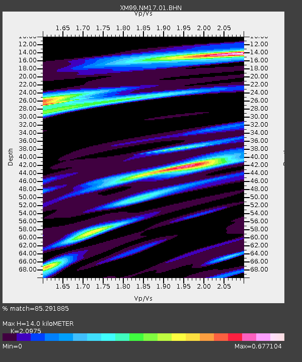
NM17 NewMexico17 - Earthquake Result Viewer

Earthquake location: Southeast Of Honshu, Japan
Earthquake latitude/longitude: 30.1/141.8
Earthquake time(UTC): 2001/04/14 (104) 23:27:26 GMT
Earthquake Depth: 10 km
Earthquake Magnitude: 6.0 MB, 5.8 MS, 6.0 MW, 6.0 ME
Earthquake Catalog/Contributor: WHDF/NEIC
Network: XM Rio Grande Seismic Transect
Station: NM17 NewMexico17
Lat/Lon: 33.26 N/105.17 W
Elevation: 1705 m
Distance: 90.7 deg
Az: 50.445 deg
Baz: 307.109 deg
Ray Param: 0.041655008
Estimated Moho Depth: 14.0 km
Estimated Crust Vp/Vs: 2.10
Assumed Crust Vp: 6.232 km/s
Estimated Crust Vs: 2.971 km/s
Estimated Crust Poisson's Ratio: 0.35
Radial Match: 85.291885 %
Radial Bump: 400
Transverse Match: 67.27718 %
Transverse Bump: 400
SOD ConfigId: 16820
Insert Time: 2010-02-26 17:25:45.481 +0000
GWidth: 2.5
Max Bumps: 400
Tol: 0.001

Signal To Noise

ChannelStoNSTALTA
XM:NM17:01:BHN:20010414T23:39:57.923Z1.12064281.5751615E-71.4055875E-7
XM:NM17:01:BHE:20010414T23:39:57.923Z1.21738311.1594956E-79.524492E-8
XM:NM17:01:BHZ:20010414T23:39:57.923Z0.97834789.103642E-89.3051185E-8
Arrivals
Ps2.5 SECOND
PpPs6.8 SECOND
PsPs/PpSs9.4 SECOND