You are here: Home > Network List > XM99 - Rio Grande Seismic Transect Stations List
> Station NM17 NewMexico17 > Earthquake Result Viewer
NM17 NewMexico17 - Earthquake Result Viewer
| Earthquake location: |
Fiji Islands Region |
| Earthquake latitude/longitude: |
-18.1/-176.9 |
| Earthquake time(UTC): |
2001/04/28 (118) 04:49:53 GMT |
| Earthquake Depth: |
352 km |
| Earthquake Magnitude: |
6.2 MB, 6.8 MW, 6.8 MW |
| Earthquake Catalog/Contributor: |
WHDF/NEIC |
|
| Network: |
XM Rio Grande Seismic Transect |
| Station: |
NM17 NewMexico17 |
| Lat/Lon: |
33.26 N/105.17 W |
| Elevation: |
1705 m |
|
| Distance: |
85.3 deg |
| Az: |
52.983 deg |
| Baz: |
245.031 deg |
| Ray Param: |
0.043932665 |
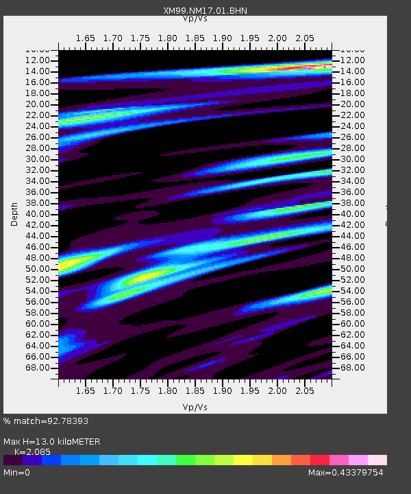
| Estimated Moho Depth: |
13.0 km |
| Estimated Crust Vp/Vs: |
2.09 |
| Assumed Crust Vp: |
6.232 km/s |
| Estimated Crust Vs: |
2.989 km/s |
| Estimated Crust Poisson's Ratio: |
0.35 |
|
| Radial Match: |
92.78393 % |
| Radial Bump: |
400 |
| Transverse Match: |
76.54055 % |
| Transverse Bump: |
400 |
| SOD ConfigId: |
4714 |
| Insert Time: |
2010-02-26 17:25:49.214 +0000 |
| GWidth: |
2.5 |
| Max Bumps: |
400 |
| Tol: |
0.001 |
|

Signal To Noise
| Channel | StoN | STA | LTA |
| XM:NM17:01:BHN:20010428T05:01:20.474006Z | 1.9932271 | 1.7879464E-7 | 8.970108E-8 |
| XM:NM17:01:BHE:20010428T05:01:20.474006Z | 4.288724 | 3.5021876E-7 | 8.166036E-8 |
| XM:NM17:01:BHZ:20010428T05:01:20.474006Z | 8.691574 | 9.045398E-7 | 1.04070885E-7 |
| Arrivals |
| Ps | 2.3 SECOND |
| PpPs | 6.3 SECOND |
| PsPs/PpSs | 8.6 SECOND |


