You are here: Home > Network List > XM99 - Rio Grande Seismic Transect Stations List
> Station NM17 NewMexico17 > Earthquake Result Viewer
NM17 NewMexico17 - Earthquake Result Viewer
| Earthquake location: |
Northern Chile |
| Earthquake latitude/longitude: |
-18.9/-69.2 |
| Earthquake time(UTC): |
1999/11/30 (334) 04:01:53 GMT |
| Earthquake Depth: |
128 km |
| Earthquake Magnitude: |
6.2 MB, 6.6 MW, 6.5 MW |
| Earthquake Catalog/Contributor: |
WHDF/NEIC |
|
| Network: |
XM Rio Grande Seismic Transect |
| Station: |
NM17 NewMexico17 |
| Lat/Lon: |
33.26 N/105.17 W |
| Elevation: |
1705 m |
|
| Distance: |
62.2 deg |
| Az: |
326.174 deg |
| Baz: |
141.025 deg |
| Ray Param: |
0.05999592 |
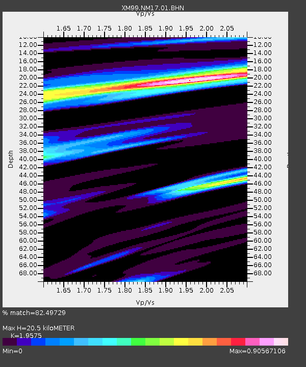
| Estimated Moho Depth: |
20.5 km |
| Estimated Crust Vp/Vs: |
1.96 |
| Assumed Crust Vp: |
6.232 km/s |
| Estimated Crust Vs: |
3.183 km/s |
| Estimated Crust Poisson's Ratio: |
0.32 |
|
| Radial Match: |
82.49729 % |
| Radial Bump: |
400 |
| Transverse Match: |
55.02204 % |
| Transverse Bump: |
400 |
| SOD ConfigId: |
27569 |
| Insert Time: |
2010-02-26 17:25:50.026 +0000 |
| GWidth: |
2.5 |
| Max Bumps: |
400 |
| Tol: |
0.001 |
|

Signal To Noise
| Channel | StoN | STA | LTA |
| XM:NM17:01:BHN:19991130T04:11:30.571013Z | 2.992425 | 6.6527133E-7 | 2.2231848E-7 |
| XM:NM17:01:BHE:19991130T04:11:30.571013Z | 1.3432736 | 4.4145335E-7 | 3.2863994E-7 |
| XM:NM17:01:BHZ:19991130T04:11:30.571013Z | 4.812309 | 1.1930885E-6 | 2.4792433E-7 |
| Arrivals |
| Ps | 3.3 SECOND |
| PpPs | 9.4 SECOND |
| PsPs/PpSs | 13 SECOND |


